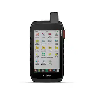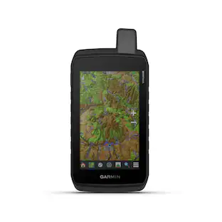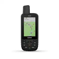
Garmin - GPSMAP 67 3" GPS with Built-In Bluetooth - Black
- Key Specs
- Screen Size: 3 inches (Size of the screen, measured diagonally from corner to corner.)
- Touch Screen: false (Touch-screen devices make navigating more intuitive. Using a touch-screen display, you can do things such as tap to select, hold and drag to move items, swipe to scroll, and pinch to zoom.)
- 3D-Map View: true
- Topographic Maps: true
- Programmable Routes: true
- App Compatible: true (The product can be connected to a program or software application on a mobile device, which then receives collected data from the product.)
- Wi-Fi Built-in: true (Able to connect directly to a wireless network without the use of an adapter.)
- General
- Brand: Garmin
- Model Number: 010-02813-00
- Product Name: GPSMAP 67 3" GPS with Built-In Bluetooth
- Color: Black
- Designed Usage: Hiking, Geocaching, Outside
- Case Included: false
- Display
- Screen Size: 3 inches (Size of the screen, measured diagonally from corner to corner.)
- Touch Screen: false (Touch-screen devices make navigating more intuitive. Using a touch-screen display, you can do things such as tap to select, hold and drag to move items, swipe to scroll, and pinch to zoom.)
- Color Display: true
- 3D-Map View: true
- Resolution: 240 x 400 (Refers to the number of pixels, both horizontally and vertically, used to capture video/images. The higher the resolution the finer the detail that can be seen.)
- Backlit Display: true (Integrated lights allow for visibility of the display in low-light conditions.)
- Display Type: TFT
- Map
- Integrated Base Maps: true
- Map Coverage Area: North America
- Number Of Waypoints: 20000
- Geocaching Mode: true
- Topographic Maps: true
- Uploadable Maps: true
- Navigation
- Programmable Routes: true
- Emergency Services Locator: true
- Electronic Compass: true
- Environmental
- Water Resistant: true (Resists some degree of water penetration.)
- Maximum Depth Of Water Resistance: 3 feet (Measurement of the maximum depth of water in which the product is able to resist some degree of water penetration.)
- Barometric Altimeter: true
- Sun/Moon Information: true
- Hunt/Fish Calendar: true
- Features
- Location Reporting: true
- Pedestrian Mode: true
- Storage
- Expandable Storage: true
- Memory Card Slot: true
- Compatibility
- App Compatible: true (The product can be connected to a program or software application on a mobile device, which then receives collected data from the product.)
- Computer Compatibility: Apple iOS, Android
- Connectivity
- Bluetooth Enabled: true (The device is capable of communicating with another device via Bluetooth, provided they are within the required range of each other. A Bluetooth-enabled device must also be the same Bluetooth version or higher than the accessory it is intended to pair with.)
- Number Of USB Port(s): 1 (The total number of USB ports including all generations and versions.)
- Wi-Fi Built-in: true (Able to connect directly to a wireless network without the use of an adapter.)
- Dimensions
- Product Height: 6.4 inches (The out of box height of the item. Height is measured as the vertical distance from the bottom of the item to the top as it would be primarily used or placed.)
- Product Width: 2.5 inches (The out of box width of the item. Width is measured as the horizontal distance from one side of the item to the other as it would be primarily used or placed.)
- Product Depth: 1.4 inches (The out of box depth of the item. Depth is measured as the distance from the front of the item to the back as it would be primarily used or placed.)
- Product Weight: 0.5 pounds (The out of box weight of the item.)
- Power
- Rechargeable Battery: true
- Battery Chemistry: Lithium-ion
- Warranty
- Warranty - Parts: 1 year limited
- Warranty - Labor: 1 year limited
- Other
- UPC: 753759308698
Go explore the outdoors with the GPSMAP 67 handheld. This premium, rugged handheld offers multi-band technology and expanded GNSS support for enhanced accuracy in steep country, urban canyons and forests with dense trees. It has a 3” color display and offers up to 180 hours of battery life in standard mode and up to 840 hours in expedition mode. It’s packed with navigation sensors, routable TopoActive mapping and access to satellite imagery. Pair it with your compatible smartphone to access active weather, Geocaching Live and the Garmin Explore app. Get access to Premium mapping content with the Outdoor Maps+ subscription.
- Sunlight-readable, transflective color, TFT display: With 240 x 400 pixel resolution for easily navigating through settings and functions.
- Compatibility: Stay tuned to the forecast with active weather on your route when paired to your Internet-enabled compatible smartphone.
- Rugged design: See your route clearly on the 3” sunlight-readable color display.
- Battery life: The internal lithium-ion rechargeable battery provides up to 180 hours of battery life in GPS mode and up to 840 hours in expedition mode.
- Multi-band GNSS support: Access multiple global navigation satellite systems (GPS, GLONASS, Galileo and QZSS). Get access to multiple frequencies sent by navigation satellites for improved position accuracy in areas where GNSS signals are reflected, weak or typically don't penetrate.
- ABC Sensors: Navigate every trail with ABC sensors, including an altimeter for elevation data, barometer to monitor weather and 3-axis electronic compass.
- Satellite imagery: Download high-resolution photorealistic maps directly to your device via Wi-Fi technology. Easily find trails, pick stand locations and parking, create waypoints and more.
- Preloaded TOPO maps: Preloaded TopoActive U.S., Mexico and Canada maps show you terrain contours, topographic elevations, summits, parks, coastlines, rivers, lakes and geographical points
- Premium map features: With an Outdoor Maps+ subscription, you get public land information, landowner names, state plat maps, hunting management unit boundaries, BLM boundaries and more (additional fees may apply).
- LED flashlight: The GPSMAP 67 series helps you keep gear to a minimum with a built-in LED flashlight that can be used as a beacon to signal for help.
- Garmin Explore app: Plan, review and sync waypoints, routes and tracks by using the Garmin Explore app on an Internet-enabled smartphone and website. You can even review completed activities while still in the field.
Whats Included
- GPSMAP 67 Series
- Type A to Type C USB Cable
- Carabiner Clip
- Documentation
Q: Can I get weather information on the GPSMAP 67?
A: Yes, you can access active weather forecasts on your route when paired with a compatible smartphone and internet connection.
Q: What type of display does the GPSMAP 67 have?
A: It features a 3-inch, sunlight-readable, transflective color TFT display with a resolution of 240 x 400 pixels.
Q: What is the maximum number of waypoints this GPS unit can store?
A: The GPSMAP 67 can store up to 20,000 waypoints.
Q: How long does the battery last on this GPS?
A: The battery lasts up to 180 hours in standard GPS mode and up to 840 hours in expedition mode.
Q: Is the GPSMAP 67 waterproof?
A: Yes, it is water-resistant up to 3 feet.
Q: Does this GPS device come with preloaded maps?
A: Yes, it comes preloaded with TopoActive maps of the U.S., Mexico, and Canada.
Q: Does the GPSMAP 67 have an altimeter?
A: Yes, it includes an altimeter for elevation data, a barometer for weather monitoring, and a 3-axis electronic compass.
Q: Can this device send and receive text message?
A: undefined
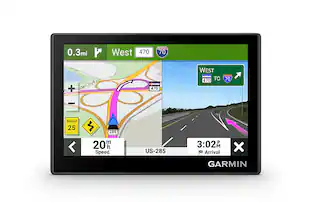
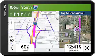
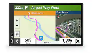
Today's top picks
 $199.99The price was $249.99
 $299.99The price was $349.99
 $399.99The price was $499.99
 $249.99The price was $299.99
 $308.49The price was $349.99