Garmin - GPSMAP 5" Marine GPS Navigator - Multi
Model: 536s
SKU: 1064483
This item is no longer available in new condition. See similar items below
- Key Specs
- Screen Size: 5 inches (Size of the screen, measured diagonally from corner to corner.)
- Chartplotter: true
- Topographic Maps: false
- App Compatible: true (The product can be connected to a program or software application on a mobile device, which then receives collected data from the product.)
- General
- Brand: Garmin
- Model Number: 536s
- Product Name: GPSMAP 5" Marine GPS Navigator
- Color: Multi
- Designed Usage: Fishing
- Display
- Screen Size: 5 inches (Size of the screen, measured diagonally from corner to corner.)
- Color Display: false
- Resolution: 480 x 640 (Refers to the number of pixels, both horizontally and vertically, used to capture video/images. The higher the resolution the finer the detail that can be seen.)
- Map
- Integrated Base Maps: true
- Map Coverage Area: U.S.
- Number Of Waypoints: 3000
- Chartplotter: true
- Topographic Maps: false
- Environmental
- Water Resistant: false (Resists some degree of water penetration.)
- Hunt/Fish Calendar: false
- Storage
- Expandable Storage: true
- Memory Card Slot: true
- Compatibility
- App Compatible: true (The product can be connected to a program or software application on a mobile device, which then receives collected data from the product.)
- Connectivity
- Bluetooth Enabled: false (The device is capable of communicating with another device via Bluetooth, provided they are within the required range of each other. A Bluetooth-enabled device must also be the same Bluetooth version or higher than the accessory it is intended to pair with.)
- Dimensions
- Product Height: 6.4 inches (The out of box height of the item. Height is measured as the vertical distance from the bottom of the item to the top as it would be primarily used or placed.)
- Product Width: 5.9 inches (The out of box width of the item. Width is measured as the horizontal distance from one side of the item to the other as it would be primarily used or placed.)
- Product Depth: 2.9 inches (The out of box depth of the item. Depth is measured as the distance from the front of the item to the back as it would be primarily used or placed.)
- Product Weight: 1.7 pounds (The out of box weight of the item.)
- Warranty
- Warranty - Parts: Not available
- Warranty - Labor: Not available
- Other
- UPC: 753759096144
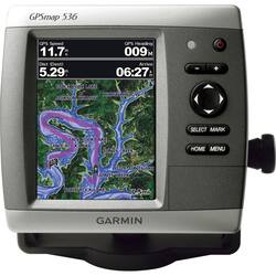
The GPSMAP 536 is a compact chartplotter that features a high-resolution, super-bright 5" VGA color display along with an improved high-speed digital design for increased map drawing and panning speeds. It's ready to go with a built-in, satellite-enhanced basemap preloaded with U.S. Inland Lakes and an easy-to-use interface designed to help you navigate the open waters with ease. The GPSMAP 536 also accepts BlueChart g2 Vision cards for added features and functionality such as high-resolution satellite imagery, 3-D views and Auto Guidance technology.
Whats Included
- GPSMAP 536s Marine GPS Navigator
- Tilt/swivel Mount
- Protective Front Cover
- Power/data Cable
- Documentation
- Dual Beam Transducer
- GPSMAP 536s Marine GPS Navigator
- Tilt/swivel Mount
- Protective Front Cover
- Power/data Cable
- Documentation
- Dual Beam Transducer