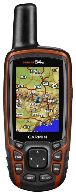
Garmin - GPSMAP 64s 2.6" Handheld GPS with Built-in Bluetooth - Orange
- Key Specs
- Screen Size: 2.6 inches (Size of the screen, measured diagonally from corner to corner.)
- Touch Screen: false (Touch-screen devices make navigating more intuitive. Using a touch-screen display, you can do things such as tap to select, hold and drag to move items, swipe to scroll, and pinch to zoom.)
- 3D-Map View: false
- Lifetime Map Updates: false
- Topographic Maps: true
- Lifetime Traffic Updates: false
- Points Of Interest: 10000
- Programmable Routes: true
- Alerts: Other
- Integrated Camera: false
- App Compatible: true (The product can be connected to a program or software application on a mobile device, which then receives collected data from the product.)
- Wi-Fi Built-in: false (Able to connect directly to a wireless network without the use of an adapter.)
- General
- Brand: Garmin
- Model Number: 010-01199-10
- Product Name: GPSMAP 64s 2.6" Handheld GPS with Built-in Bluetooth
- Color: Orange
- Designed Usage: Geocaching, Hiking, Outside
- Case Included: false
- Display
- Screen Size: 2.6 inches (Size of the screen, measured diagonally from corner to corner.)
- Touch Screen: false (Touch-screen devices make navigating more intuitive. Using a touch-screen display, you can do things such as tap to select, hold and drag to move items, swipe to scroll, and pinch to zoom.)
- Color Display: true
- 3D-Map View: false
- Resolution: 160 x 240 (Refers to the number of pixels, both horizontally and vertically, used to capture video/images. The higher the resolution the finer the detail that can be seen.)
- Backlit Display: true (Integrated lights allow for visibility of the display in low-light conditions.)
- Map
- Lifetime Map Updates: false
- Integrated Base Maps: true
- Map Coverage Area: Worldwide
- Map Sharing: false
- Map Provider: Other
- Number Of Waypoints: 5000
- Geocaching Mode: true
- Topographic Maps: true
- Uploadable Maps: true
- Navigation
- Lifetime Traffic Updates: false
- Points Of Interest: 10000
- Programmable Routes: true
- Voice Prompts: false
- Emergency Services Locator: false
- Electronic Compass: true
- Environmental
- Water Resistant: true (Resists some degree of water penetration.)
- Maximum Depth Of Water Resistance: 3.28 feet (Measurement of the maximum depth of water in which the product is able to resist some degree of water penetration.)
- Barometric Altimeter: true
- Sun/Moon Information: true
- Hunt/Fish Calendar: true
- Features
- Location Reporting: true
- Alerts: Other
- Integrated Camera: false
- Pedestrian Mode: true
- Hand Strap: false
- Text-To-Speech: false (A system that converts language text into speech.)
- MP3 Playback: false
- Storage
- Expandable Storage: true
- Memory Card Slot: true
- Memory Card Included: false (Indicates whether a memory card is included.)
- Compatibility
- App Compatible: true (The product can be connected to a program or software application on a mobile device, which then receives collected data from the product.)
- Computer Compatibility: Mac, Windows
- Unit-To-Unit Transfer: true
- Automatic Sync: true
- Works With: Cortana, Siri (Compatible with or able to be connected to other smart devices or applications.)
- Connectivity
- Bluetooth Enabled: true (The device is capable of communicating with another device via Bluetooth, provided they are within the required range of each other. A Bluetooth-enabled device must also be the same Bluetooth version or higher than the accessory it is intended to pair with.)
- Number Of USB Port(s): 1 (The total number of USB ports including all generations and versions.)
- Wi-Fi Built-in: false (Able to connect directly to a wireless network without the use of an adapter.)
- Dimensions
- Product Height: 6.38 inches (The out of box height of the item. Height is measured as the vertical distance from the bottom of the item to the top as it would be primarily used or placed.)
- Product Width: 2.5 inches (The out of box width of the item. Width is measured as the horizontal distance from one side of the item to the other as it would be primarily used or placed.)
- Product Depth: 1.5 inches (The out of box depth of the item. Depth is measured as the distance from the front of the item to the back as it would be primarily used or placed.)
- Product Weight: 0.57 pounds (The out of box weight of the item.)
- Warranty
- Warranty - Parts: 1 year limited
- Warranty - Labor: 1 year limited
- Other
- UPC: 753759115838
With a 1-year subscription to BirdsEye Satellite Imagery, this Garmin GPSMAP 64s 010-01199-10 handheld GPS offers a true outdoor visual representation. The 3-axis compass shows your heading, and the barometric altimeter pinpoints your precise altitude.
- Built-in worldwide base map: With shaded relief, along with a 1-year subscription to BirdsEye Satellite Imagery, allows you to navigate with ease. Photo navigation lets you download geotagged pictures from the Internet and then navigate to them.
- Quad-helix antenna: Tracks both GPS and GLONASS satellites simultaneously to quickly locate your position and maintain your location, even in heavy cover and deep canyons.
- 2.6" transflective TFT color screen: With 160 x 240 pixels showcases information in easy-to-read detail, even in direct sunlight. The water-resistant design withstands moisture damage.
- Bluetooth and ANT+ technologies: Let you wirelessly share waypoints, tracks, routes and geocaches to other enabled devices, including select Garmin handheld GPS units.
- 4GB internal memory: Offers generous storage space. The microSD card slot enables you to download additional topographic, marine and road maps for simple system expansion.
Whats Included
- Carabiner clip
- Garmin GPSMAP 64s 2.6" Handheld GPS with Built-in Bluetooth
- Owner's manual
- USB cable
Q: Can thisGPS pinpoint the pins on my land
A: Hello, Yes, you would be able locating your pins on your land using the GPSMAP 64s. Thanks Chris
Q: Can this be used worldwide? Option to change language to French? Measurements to kilometer?
A: Hi Yao, Yes, this unit can be used worldwide and have the option to change language to French. Yes, you can change units to kilometer on the unit as well. Thanks Chris
Q: What company makes the best and easiest to use Handheld GPS for Fishing and Hunting?
A: Hello, With the GPSMAP 64s would be a good device to use for fishing and hunting. The device has the abiltiy to mark waypoint and track location. Thanks Chris
A: Hello, You will not lose any functionality on the device. You will not be able to download any new Birdseye images after the year expires. If you want to purchase a new subscription of Birdseye the cost is $29.99 USD. Thanks Chris
Q: Can i enter coordinates to a particular spot
A: Hello, Yes, with the GPSMAP 64s you will be able to enter coordinates to a particular spot. Thanks Chris
A: Hello Yandy, The GPSMAP 64s and GPSMAP 64st both have the same GPS accuracy. The difference between the units are more features. The GPSMAP 64st has 8GB internal memory and preloaded with TOPO map of US or Canada. Thanks Chris
Q: Is there a possibility the manual in Spanish?
A: Hi Jorge, Yes, you can get the manual in Spanish. Below is a link to our manual in Spanish. http://static.garmin.com/pumac/GPSMAP64_OM_ES.pdf Thanks Chris
Q: Can the GPSMAP 64s be used to navigate in cities with vehicles?
A: I have used for city navigation. It has city maps included with my gpsmap 64s
People also viewed
 $312.99The price was $349.99
 $499.99The price was $599.99
 $420.99The price was $449.99
Today's top picks
 $199.99The price was $249.99
 $479.99The price was $729.99
 $789.99The price was $1,049.99
 $799.99The price was $1,199.99