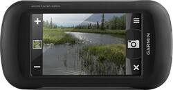
Garmin - Montana 680t 4" Handheld GPS with Built-In Camera - Black/Gray
- Key Specs
- Screen Size: 4 inches (Size of the screen, measured diagonally from corner to corner.)
- Touch Screen: true (Touch-screen devices make navigating more intuitive. Using a touch-screen display, you can do things such as tap to select, hold and drag to move items, swipe to scroll, and pinch to zoom.)
- 3D-Map View: true
- Lifetime Map Updates: false
- Topographic Maps: true
- Lifetime Traffic Updates: false
- Programmable Routes: true
- Alerts: Other
- Integrated Camera: true
- App Compatible: true (The product can be connected to a program or software application on a mobile device, which then receives collected data from the product.)
- Wi-Fi Built-in: false (Able to connect directly to a wireless network without the use of an adapter.)
- General
- Brand: Garmin
- Model Number: 010-01534-11
- Product Name: Montana 680t 4" Handheld GPS with Built-In Camera
- Color: Black/Gray
- Designed Usage: Hiking
- Case Included: false
- Number Of Languages Supported: 5
- Display
- Screen Size: 4 inches (Size of the screen, measured diagonally from corner to corner.)
- Touch Screen: true (Touch-screen devices make navigating more intuitive. Using a touch-screen display, you can do things such as tap to select, hold and drag to move items, swipe to scroll, and pinch to zoom.)
- Color Display: true
- 3D-Map View: true
- Resolution: 272 x 480 (Refers to the number of pixels, both horizontally and vertically, used to capture video/images. The higher the resolution the finer the detail that can be seen.)
- Backlit Display: true (Integrated lights allow for visibility of the display in low-light conditions.)
- Map
- Lifetime Map Updates: false
- Integrated Base Maps: true
- Map Coverage Area: Worldwide, U.S.
- Map Sharing: false
- Map Provider: Navteq
- Number Of Waypoints: 4000
- Geocaching Mode: true
- Topographic Maps: true
- Uploadable Maps: false
- Navigation
- Lifetime Traffic Updates: false
- Programmable Routes: true
- Voice Prompts: false
- Emergency Services Locator: false
- Electronic Compass: true
- Environmental
- Water Resistant: true (Resists some degree of water penetration.)
- Maximum Depth Of Water Resistance: 3 feet (Measurement of the maximum depth of water in which the product is able to resist some degree of water penetration.)
- Barometric Altimeter: true
- Sun/Moon Information: true
- Hunt/Fish Calendar: true
- Features
- Location Reporting: false
- Alerts: Other
- Integrated Camera: true
- Pedestrian Mode: true
- Text-To-Speech: false (A system that converts language text into speech.)
- MP3 Playback: false
- Storage
- Expandable Storage: true
- Memory Card Slot: true
- Memory Card Included: false (Indicates whether a memory card is included.)
- Compatibility
- App Compatible: true (The product can be connected to a program or software application on a mobile device, which then receives collected data from the product.)
- Computer Compatibility: Windows, Mac
- Unit-To-Unit Transfer: true
- Automatic Sync: false
- Works With: Cortana, Apple Home (Compatible with or able to be connected to other smart devices or applications.)
- Connectivity
- Bluetooth Enabled: false (The device is capable of communicating with another device via Bluetooth, provided they are within the required range of each other. A Bluetooth-enabled device must also be the same Bluetooth version or higher than the accessory it is intended to pair with.)
- Number Of USB Port(s): 1 (The total number of USB ports including all generations and versions.)
- Wi-Fi Built-in: false (Able to connect directly to a wireless network without the use of an adapter.)
- Dimensions
- Product Height: 5.7 inches (The out of box height of the item. Height is measured as the vertical distance from the bottom of the item to the top as it would be primarily used or placed.)
- Product Width: 2.9 inches (The out of box width of the item. Width is measured as the horizontal distance from one side of the item to the other as it would be primarily used or placed.)
- Product Depth: 1.4 inches (The out of box depth of the item. Depth is measured as the distance from the front of the item to the back as it would be primarily used or placed.)
- Product Weight: 0.75 pounds (The out of box weight of the item.)
- Power
- Rechargeable Battery: true
- Battery Life: 16 hours (Battery life will vary depending on the product configuration, product model, applications loaded on the product, power management setting of the product and the product features used by the customer. As with all batteries, the maximum capacity of this battery will decrease with time and usage.)
- Battery Chemistry: Lithium-ion
- Interface(s): USB (Refers to the types of connections that devices use to interact and communicate with each other.)
- Warranty
- Warranty - Parts: 1 year limited
- Warranty - Labor: 1 year limited
- Other
- UPC: 753759143350
Garmin Montana 680t Handheld GPS: Discover new hiking trails and beautiful scenery with GPS, which features preloaded worldwide and U.S. topographic base maps and a bright 4" touch screen for simple navigation. The 8.0MP camera lets you geotag your favorite destinations, so you can find them again later.
- Detailed worldwide and topographic U.S. maps: Preloaded worldwide and TOPO U.S. 100K base map coverage, as well as over 250,000 preloaded worldwide geocaches. Also includes 1-year BirdsEye Satellite Imagery for detailed aerial images.
- 4" backlit TFT display offers clear visibility in direct sunlight: Glove-friendly touch screen makes it easy to program settings and destinations.
- Precise navigation, even in deep woods or canyons: WAAS-enabled GPS with GLONASS support and 3-axis tilt-compensated electronic compass locates your position quickly and accurately.
- 8.0MP digital camera helps you remember your favorite spots: Capture crisp images of your favorite scenery, and geotag coordinates so you can return to them in the future.
- Upload even more maps and coordinates: 2GB internal memory allows you to save photos and load more maps. Expand storage using the microSD slot (memory card not included).
Whats Included
- Montana 680t 4" Handheld GPS with Built-In Camera
- Lithium-ion battery pack
- AC charger, USB cable
- Owner's manual
Q: Would this be the best GPS for an avid duck hunter?
A: You would probably be better with a boat mounted GPS as it would have more features pertaining to water. This is an all around good GPS that can be adapted to pretty much any need but extra money for the correct maps must be spent to enjoy these extra features.
Q: is this a dash cam as well as a gps tracker
A: The Montana 680t is not designed to be a dash cam for recording accidents, but does feature GPS with GLONASS. ^DK
Q: can you put in latitude and lontitude poiant and navigate between them
A: You can use the Where To? menu to find a destination to navigate to. For more information contact us at [email protected] or visit our Support Center, https://support.garmin.com/en-US/. Thanks Jenny
Q: Does the 680t come with any road maps?
A: The Montana 680t comes with topographic maps which will include some road mapping. However if you need detailed road maps with road routing capabilities then you will want to additionally purchase City Navigator NT mapping.
Q: Is this a brand-new unopened unit
A: This will be new in box.
Q: will my maps form city nav 2008 and Canada v2 topo us topo work in the 680t
A: Hi, Unfortunately the City Navigator 2008 map will not work with the Montana 680t. The 2 TOPO maps will work with the device as long as they are on either DVD or preloaded micro SD card. Thanks Chris
A: If a picture that was taken on the Montana 680t is printed, only the image prints. The geographic location that's saved with the photo information is electronic and is meant to be used for you to navigate back to the spot where the picture was taken. Additional notes can not be added to the photos. Thanks! (KS)
Q: Can you order the Canada topo map instead of the US for the Montana 680t
A: We do sell a Montana 680 that does not come preloaded with Topo maps. The reduced cost will make it more affordable for you to purchase the Topo maps you'd like if the US topo maps won't be of use for you. -JPK