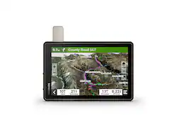
Garmin - Tread - Overland Edition 8" GPS with Built-In Bluetooth - Black
- Key Specs
- Screen Size: 8 inches (Size of the screen, measured diagonally from corner to corner.)
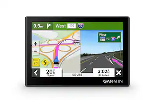
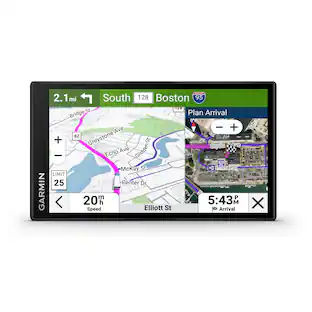
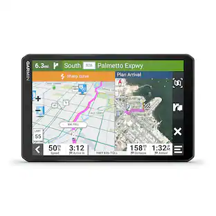
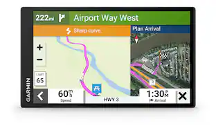
- Touch Screen: true (Touch-screen devices make navigating more intuitive. Using a touch-screen display, you can do things such as tap to select, hold and drag to move items, swipe to scroll, and pinch to zoom.)
- 3D-Map View: true
- Topographic Maps: true
- Programmable Routes: true
- Alerts: Incoming call, Incoming text, Railroad crossings, Rest areas, School zones
- App Compatible: true (The product can be connected to a program or software application on a mobile device, which then receives collected data from the product.)
- Wi-Fi Built-in: true (Able to connect directly to a wireless network without the use of an adapter.)
- General
- Brand: Garmin
- Model Number: 010-02508-00
- Product Name: Tread - Overland Edition 8" GPS with Built-In Bluetooth
- Color: Black
- Designed Usage: Car, Outdoor
- Case Included: false
- Display
- Screen Size: 8 inches (Size of the screen, measured diagonally from corner to corner.)
- Touch Screen: true (Touch-screen devices make navigating more intuitive. Using a touch-screen display, you can do things such as tap to select, hold and drag to move items, swipe to scroll, and pinch to zoom.)
- Color Display: true
- 3D-Map View: true
- Resolution: 1280 x 800 (Refers to the number of pixels, both horizontally and vertically, used to capture video/images. The higher the resolution the finer the detail that can be seen.)
- Backlit Display: true (Integrated lights allow for visibility of the display in low-light conditions.)
- Display Type: TFT
- Map
- Integrated Base Maps: true
- Map Coverage Area: North America
- Topographic Maps: true
- Uploadable Maps: true
- Navigation
- Programmable Routes: true
- Voice Prompts: true
- Emergency Services Locator: true
- Electronic Compass: true
- Environmental
- Water Resistant: true (Resists some degree of water penetration.)
- Maximum Depth Of Water Resistance: 3 feet (Measurement of the maximum depth of water in which the product is able to resist some degree of water penetration.)
- Barometric Altimeter: true
- Features
- Location Reporting: true
- Alerts: Incoming call, Incoming text, Railroad crossings, Rest areas, School zones
- Pedestrian Mode: false
- MP3 Playback: false
- Storage
- Expandable Storage: true
- Memory Card Slot: true
- Memory Card Included: false (Indicates whether a memory card is included.)
- Compatibility
- App Compatible: true (The product can be connected to a program or software application on a mobile device, which then receives collected data from the product.)
- Computer Compatibility: Apple iOS, Android
- Connectivity
- Bluetooth Enabled: true (The device is capable of communicating with another device via Bluetooth, provided they are within the required range of each other. A Bluetooth-enabled device must also be the same Bluetooth version or higher than the accessory it is intended to pair with.)
- Number Of USB Port(s): 1 (The total number of USB ports including all generations and versions.)
- Wi-Fi Built-in: true (Able to connect directly to a wireless network without the use of an adapter.)
- Dimensions
- Product Height: 6.7 inches (The out of box height of the item. Height is measured as the vertical distance from the bottom of the item to the top as it would be primarily used or placed.)
- Product Width: 8.1 inches (The out of box width of the item. Width is measured as the horizontal distance from one side of the item to the other as it would be primarily used or placed.)
- Product Depth: 1.2 inches (The out of box depth of the item. Depth is measured as the distance from the front of the item to the back as it would be primarily used or placed.)
- Product Weight: 2 pounds (The out of box weight of the item.)
- Power
- Rechargeable Battery: true
- Battery Life: 6 hours (Battery life will vary depending on the product configuration, product model, applications loaded on the product, power management setting of the product and the product features used by the customer. As with all batteries, the maximum capacity of this battery will decrease with time and usage.)
- Battery Chemistry: Lithium-ion polymer
- Interface(s): USB (Refers to the types of connections that devices use to interact and communicate with each other.)
- Charging Method: 12V cigarette lighter, USB
- Mounting
- Mount Included: true
- Mount
- Mount Type: Suction cup
- Warranty
- Warranty - Parts: 1 year limited
- Warranty - Labor: 1 year limited
- Other
- UPC: 753759277567
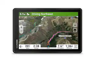
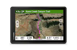
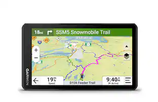
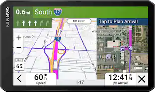
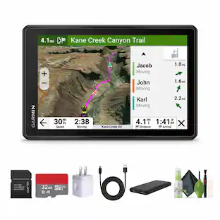
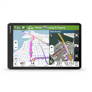
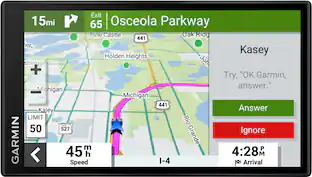
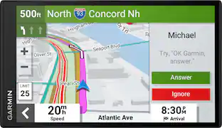
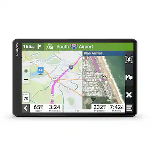
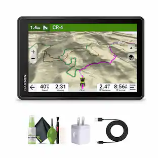
Roam the unknown with Tread – Overland Edition. It’s the rugged all-terrain navigator with an 8” ultrabright display made for every overlanding expedition. Enjoy turn-by-turn trail navigation for traversing unpaved roads and trails. (Limitations may exist in map data for some road and trail route suggestions. Always defer to all posted road signs and conditions during vehicle operation. The Garmin OpenStreetMap products are intended to be used only as a supplementary travel aid and must not be used for any purpose requiring precise measurement of direction, distance, location or topography.) Custom street routing takes into account the size and weight of your rig. (Not available in all areas. Entering your vehicle’s profile characteristics does not guarantee your vehicle’s characteristics will be accounted for in all route suggestions. Always defer to all posted road signs and road conditions.) The navigator includes preloaded topography, subscription-free BirdsEye Satellite Imagery, iOverlander points of interest and Ultimate Public Campgrounds, so you won’t need a signal to route to the best-established, wild and dispersed campsites. With an active satellite subscription, built-in inReach technology offers global satellite communication, two-way text messaging, location sharing, and interactive SOS (Some jurisdictions regulate or prohibit the use of satellite communications devices). Pair your device to the Tread app on your compatible smartphone to track up to 20 friends using the Group Ride Mobile feature and plan routes with the same maps and route preferences that you have on the Tread device. (Tracking via Group Ride Mobile requires the Tread app running on your and each friend’s compatible smartphone with BLUETOOTH technology and an active cellular connection.)
- *Rugged design: Rugged, weather-resistant all-terrain navigator with an 8” ultrabright display; includes locking magnet-assisted mount for securing in your rig
- **Trail navigation: Turn-by-turn trail navigation for traversing unpaved roads and trails using adventure roads and trails map content
- ***Custom routing: Comprised of OSM, and USFS Motor Vehicle Use Maps; City Navigator road maps for custom street routing takes into account the size and weight of your rig.
- Topography and land boundaries: Preloaded topographic maps with 3D terrain of North and South America, U.S. public and private landowner information and subscription-free BirdsEye Satellite Imagery via direct-to-device download
- Built-in inReach technology: Built-in inReach technology offers global satellite communication, two-way text messaging, location sharing, and interactive SOS. (Requires an active subscription. Some jurisdictions regulate or prohibit the use of satellite communications devices.)
- Directory of campgrounds: Preloaded with iOverlander points of interest and Ultimate Public Campgrounds, so you don’t need a cell signal to route to the best-established, wild and dispersed campsites
- ****Easy route planning: Pair with the Tread app on your compatible smartphone to track friends using the Group Ride Mobile feature, sync your trip data across all your devices, and plan routes with the same maps, vehicle profiles and route preferences that you have on the Tread device
- Gauges and sensors: Built-in altimeter, barometer, compass, and pitch and roll gauges help you navigate challenging terrain
- *****Compatibility: Works with other Garmin off-road products, including the Group Ride Radio for group tracking and communication plus the Garmin PowerSwitch digital switch box (each sold separately).
- *Disclaimer: IP67; Dust tight. Withstands ingress of dust with vacuum applied. Withstands incidental exposure to water of up to 1 meter for up to 30 minutes
- **Disclaimer: Limitations may exist in map data for some road and trail route suggestions. Always defer to all posted road signs and conditions during vehicle operation. The Garmin OpenStreetMap products are intended to be used only as a supplementary travel aid.
- ***Disclaimer: Not available in all areas. Entering your vehicle’s profile characteristics does not guarantee your vehicle’s characteristics will be accounted for in all route suggestions. Always defer to all posted road signs and road conditions.
- ****Disclaimer: Tracking via Group Ride Mobile requires the Tread app running on your and each friend’s compatible smartphone with BLUETOOTH technology and an active cellular connection.
- *****Disclaimer: Group tracking is available for riders using a Tread navigator, and only riders with a Tread navigator may be tracked. Connection to vehicle power is required for group tracking and push-to-talk mic functionality.
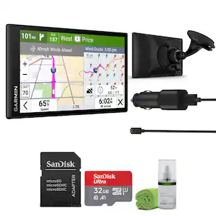
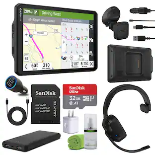
Whats Included
- Tread Overland
- Suction Cup Mount
- Vehicle Power Cable
- Locking Magnetic Assisted Mount
- USB Cable
- Docemantation
Q: Does this GPS device come with preloaded topographic maps?
A: Yes, it comes preloaded with topographic maps with 3D terrain of North and South America.
Q: Does this GPS navigator have a touch screen?
A: Yes, this GPS navigator has a touch screen.
Q: Can I use this device to navigate trails?
A: Yes, it offers turn-by-turn trail navigation for traversing unpaved roads and trails using adventure roads and trails map content.
Q: What is the screen size of this GPS device?
A: The screen size of this GPS device is 8 inches.
Q: How long does the battery last on a single charge?
A: The battery lasts for 6 hours on a single charge.
People also viewed
 $899.99The price was $999.99
 $312.99The price was $349.99
 $719.95The price was $724.95
Today's top picks
- $312.99The price was $349.99
 $523.99The price was $599.99
 $478.00The price was $499.99