Garmin - GPSMAP 1242xsv Fishfinder/Chartplotter GPS - Black
Related Item

Specifications
- Screen Size12.1 inchesChartplotterYesTopographic MapsYesProgrammable RoutesYesApp CompatibleYesDepthfinderYes
- Key Specs
- Screen Size: 12.1 inches (Size of the screen, measured diagonally from corner to corner.)
- Chartplotter: true
- Topographic Maps: true
- Programmable Routes: true
- App Compatible: true (The product can be connected to a program or software application on a mobile device, which then receives collected data from the product.)
- Depthfinder: true
- Fish Finder: true
- General
- Brand: Garmin
- Model Number: 010-01741-60
- Product Name: GPSMAP 1242xsv Fishfinder/Chartplotter GPS
- Color: Black
- Designed Usage: Boating
- Case Included: false
- Display
- Screen Size: 12.1 inches (Size of the screen, measured diagonally from corner to corner.)
- Color Display: true
- Resolution: 1280 x 800 (Refers to the number of pixels, both horizontally and vertically, used to capture video/images. The higher the resolution the finer the detail that can be seen.)
- Backlit Display: true (Integrated lights allow for visibility of the display in low-light conditions.)
- Display Type: LCD
- Fish Icon Display: true
- Map
- Integrated Base Maps: true
- Map Coverage Area: North America
- Map Sharing: true
- Number Of Waypoints: 5000
- Chartplotter: true
- Topographic Maps: true
- HD Mapping: true
- Optional Chart Upgrades: true
- Navigation
- Programmable Routes: true
- Electronic Compass: true
- Environmental
- Water Resistant: true (Resists some degree of water penetration.)
- Sun/Moon Information: true
- Hunt/Fish Calendar: true
- Storage
- Expandable Storage: true
- Memory Card Slot: true
- Compatibility
- App Compatible: true (The product can be connected to a program or software application on a mobile device, which then receives collected data from the product.)
- Computer Compatibility: Android, Apple iOS
- Unit-To-Unit Transfer: true
- Connectivity
- Bluetooth Enabled: true (The device is capable of communicating with another device via Bluetooth, provided they are within the required range of each other. A Bluetooth-enabled device must also be the same Bluetooth version or higher than the accessory it is intended to pair with.)
- Depthfinding
- Depthfinder: true
- Downscan Imaging: true
- Side Imaging: true
- Fish Finder: true
- Sonar Compatible: Yes
- Dimensions
- Product Height: 8.9 inches (The out of box height of the item. Height is measured as the vertical distance from the bottom of the item to the top as it would be primarily used or placed.)
- Product Width: 13 inches (The out of box width of the item. Width is measured as the horizontal distance from one side of the item to the other as it would be primarily used or placed.)
- Product Depth: 3.1 inches (The out of box depth of the item. Depth is measured as the distance from the front of the item to the back as it would be primarily used or placed.)
- Product Weight: 5.8 pounds (The out of box weight of the item.)
- Power
- Power Source: Hard wired
- Mounting
- GPS Mount Type: Bail, Flush
- Warranty
- Warranty - Parts: 1 year limited
- Warranty - Labor: 1 year limited
- Other
- UPC: 753759285234
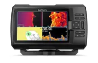
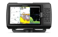
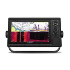
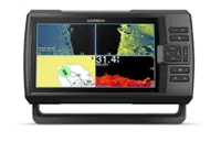
Experience an advanced all-in-one solution with our 12” GPSMAP 1242xsv keyed combo. It features a large, bright screen coupled with a keypad interface and multifunction control knob. A GT52-TM transducer is included for Garmin CHIRP sonar along with CHIRP ClearVü and CHIRP SideVü scanning sonars. There’s also support for Panoptix and LiveScope sonar products and a wide range of other transducers (sold separately). Preloaded Garmin Navionics+ coastal charts and inland mapping feature Auto Guidance+ technology (Auto Guidance+ is for planning purposes only and does not replace safe navigation operations). Plus, there’s support for optional Garmin Navionics Vision+ premium map content. The combo also includes Quickdraw Contours software and the Quickdraw Community on our Garmin Connect online network. Use built-in Wi-Fi technology to pair with the free ActiveCaptain smartphone app for access to the OneChart feature, smart notifications, Garmin Quickdraw Community data and more. Garmin Marine Network support allows sharing of sonar, maps, user data, radar, IP cameras and live sonar among multiple units. Plus, there’s NMEA 2000 and NMEA 0183 network connectivity support, including autopilots, digital switching, weather, media, VHF, AIS and other sensors. These units also include integrated ANT connectivity support for use with compatible quatix smartwatches, the gWind Wireless 2 transducer, GNX Wind marine instrument and remote controls (sold separately). See RPMs, fuel flow, temperature, trim and more for up to four of your compatible Mercury engines by using the SmartCraft Connect gateway.
- Sonar capable: The chartplotters include built-in single-channel CHIRP sonar plus CHIRP ClearVü and CHIRP SideVü scanning sonars with Panoptix and LiveScope sonar support on select models (transducers sold separately).
- Built-in ANT connectivity: Enjoy built-in ANT wireless connectivity directly to your compatible Garmin devices such as quatix marine watches, gWind Wireless 2 transducers, GNX Wind marine instruments and wireless remote controls.
- Connected ActiveCaptain app: Built in Wi-Fi technology gives you access to the free all-in-one ActiveCaptain app, so you can manage your marine experience from nearly anywhere on your compatible smartphone.
- Garmin Sailassist feature: Use the polar table to view important data fields to help you trim your sails for maximum speed and efficiency. You can also see laylines, set and drift, true and apparent wind data (sensor sold separately), and more.
- Upgrade charts and maps: Optional Garmin Navionics Vision+ cartography provides high-resolution relief shading, satellite photos, Auto Guidance+ technology and more.
- Smooth tracking: The fast, responsive built-in 10 Hz GPS and GLONASS receiver refreshes your position and heading 10 times each second to make your movement on the screen more fluid.
- Preloaded mapping: Select a chartplotter with our built-in worldwide basemap or Garmin Navionics+ coastal charts and inland mapping with Auto Guidance+ technology.
- Network capable: The GPSMAP chartplotters are fully network capable for the Garmin Marine Network and NMEA 2000 networking plus NMEA 0183 technology support.
- GPX waypoints transfer: Easily transfer waypoints, tracks or frequently used routes from other devices via industry standard GPX software formatting.
- Complete network sharing: Garmin Marine Network support allows sharing of sonar, maps, user data, dome or open-array radar, and Panoptix and LiveScope sonars among multiple units.
- Engine connectivity: Read RPMs, fuel flow, temperature, trim and other important information at a glance. Check with your engine manufacturer for additional hardware needs.
Whats Included
- GPSMAP 1242xsv chartplotter
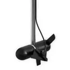
- GT52HW-TM transducer
- Power/data cable
- NMEA 2000 T-connector
- NMEA 2000 drop cable (2 m)
- Transducer
- Bail mount kit with knobs
- Flush mount kit with gasket
- Protective cover and Trim piece snap covers
- Documentation
- GPSMAP 1242xsv chartplotter
- GT52HW-TM transducer
- Power/data cable
- NMEA 2000 T-connector
- NMEA 2000 drop cable (2 m)
- Transducer
- Bail mount kit with knobs
- Flush mount kit with gasket
- Protective cover and Trim piece snap covers
- Documentation
Q: Is this device compatible with smartphones?
A: Yes, the built-in Wi-Fi technology allows you to pair it with the ActiveCaptain smartphone app.
Q: Does the GPSMAP 1242xsv support engine connectivity?
A: Yes, you can check RPMs, fuel flow, temperature, trim and other important information. You may need to check with your engine manufacturer for additional hardware requirements.
Q: Can I share data with other devices?
A: Yes, Garmin Marine Network support allows sharing of sonar, maps, user data, radar, IP cameras and live sonar among multiple units.
Q: What is the screen resolution of this GPSMAP?
A: The screen resolution is 1280 x 800.
Q: What comes with the GPSMAP 1242xsv?
A: It comes with a GT52-TM transducer for Garmin CHIRP sonar along with CHIRP ClearVü and CHIRP SideVü scanning sonars.
Q: How many waypoints can this device store?
A: This GPSMAP can store up to 5000 waypoints.
Q: Does this device have preloaded maps?
A: Yes, it comes with preloaded Garmin Navionics+ coastal charts and inland mapping.
Q: Can this be used with a Simrad TP-22 tiller pilot?
A: The 1242xsv has NMEA 0183 and NMEA 2000 capability. If the Simrad pilot uses either of these, it can be connected.
Compare similar products

Experience an advanced all-in-one solution with our 12” GPSMAP 1242xsv keyed combo. It features a large, bright screen coupled with a keypad interface and multifunction control knob. A GT52-TM transducer is included for Garmin CHIRP sonar along with CHIRP ClearVü and CHIRP SideVü scanning sonars. There’s also support for Panoptix and LiveScope sonar products and a wide range of other transducers (sold separately). Preloaded Garmin Navionics+ coastal charts and inland mapping feature Auto Guidance+ technology (Auto Guidance+ is for planning purposes only and does not replace safe navigation operations). Plus, there’s support for optional Garmin Navionics Vision+ premium map content. The combo also includes Quickdraw Contours software and the Quickdraw Community on our Garmin Connect online network. Use built-in Wi-Fi technology to pair with the free ActiveCaptain smartphone app for access to the OneChart feature, smart notifications, Garmin Quickdraw Community data and more. Garmin Marine Network support allows sharing of sonar, maps, user data, radar, IP cameras and live sonar among multiple units. Plus, there’s NMEA 2000 and NMEA 0183 network connectivity support, including autopilots, digital switching, weather, media, VHF, AIS and other sensors. These units also include integrated ANT connectivity support for use with compatible quatix smartwatches, the gWind Wireless 2 transducer, GNX Wind marine instrument and remote controls (sold separately). See RPMs, fuel flow, temperature, trim and more for up to four of your compatible Mercury engines by using the SmartCraft Connect gateway.

Experience an advanced all-in-one solution with our 10” GPSMAP 1042xsv keyed combo. It features a large, bright screen coupled with a keypad interface and multifunction control knob. A GT52-TM transducer is included for Garmin CHIRP sonar along with CHIRP ClearVü and CHIRP SideVü scanning sonars. There’s also support for Panoptix and LiveScope sonar products and a wide range of other transducers (sold separately). Preloaded Garmin Navionics+ coastal charts and inland mapping feature Auto Guidance+ technology (Auto Guidance+ is for planning purposes only and does not replace safe navigation operations). Plus, there’s support for optional Garmin Navionics Vision+ premium map content. The combo also includes Quickdraw Contours software and the Quickdraw Community on our Garmin Connect online network. Use built-in Wi-Fi technology to pair with the free ActiveCaptain smartphone app for access to the OneChart feature, smart notifications, Garmin Quickdraw Community data and more. Garmin Marine Network support allows sharing of sonar, maps, user data, radar, IP cameras and live sonar among multiple units. Plus, there’s NMEA 2000 and NMEA 0183 network connectivity support, including autopilots, digital switching, weather, media, VHF, AIS and other sensors. These units also include integrated ANT connectivity support for use with compatible quatix smartwatches, the gWind Wireless 2 transducer, GNX Wind marine instrument and remote controls (sold separately). See RPMs, fuel flow, temperature, trim and more for up to four compatible Mercury engines by using the SmartCraft Connect gateway.

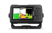
The 9” ECHOMAP™ UHD2 touchscreen with keyed-assist chartplotter knows the water better than a local. Its high-resolution display offers improved detail, clarity and viewing angle. See clear, sharp fish arches with Garmin traditional sonar. ClearVü™ and SideVü™ scanning sonars feature vivid color palettes for clear, high-contrast views all around your boat. ECHOMAP UDH2 also supports LiveScope™ sonar systems. Navigate the waters with built-in Garmin Navionics+™ cartography. Built-in Wi-Fi® connectivity lets you wirelessly share sonar, waypoints and routes with another ECHOMAP UHD2 chartplotter. Wherever you drop your line, get improved position accuracy, particularly in areas where signals are reflected or weak, with multi-band GPS. You can also pair with the free all-in-one ActiveCaptain® app on your compatible smartphone for access to the OneChart™ feature, software updates and more. The chartplotter supports NMEA 2000® networks to connect your compatible autopilots, digital switching, music, and more to view all on one screen.

See fish and structure in colorful detail with the STRIKER Vivid 9sv fishfinder. This easy-to-use 9” device now features high-contrast color palettes to make it easier to see what’s beneath the surface. It includes support for best-in-class Garmin CHIRP traditional sonar plus CHIRP ClearVü and CHIRP SideVü scanning sonars (requires compatible transducer). High sensitivity GPS lets you mark hot spots, plan routes and view your boat’s speed. Create and save maps with 1’ contours with built-in Quickdraw Contours software. Built-in Wi-Fi connectivity allows you to connect to the ActiveCaptain app with compatible smartphone to transfer waypoints, receive smart notifications and access the Garmin Quickdraw Community.
| Pros for Garmin - GPSMAP 1242xsv Fishfinder/Chartplotter GPS - Black | |||
|---|---|---|---|
| There were no pros for this product— | There were no pros for this product— | Customer assistance | There were no pros for this product— |
Specs
Reviews
Customer Images
The vast majority of our reviews come from verified purchases. Reviews from customers may include My Best Buy members, employees, and Tech Insider Network members (as tagged). Select reviewers may receive discounted products, promotional considerations or entries into drawings for honest, helpful reviews.
- Rated 5 out of 5 stars
No complaints
Such a great product and great quality build. Comes with everything in the box that some other sites don’t come with different pieces in the box.
Alejandro Posted