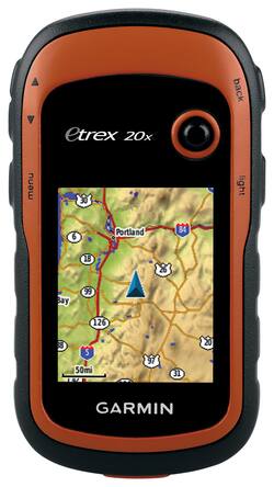
Garmin - eTrex 20x 2.2" GPS - Orange
- Key Specs
- Screen Size: 2.2 inches (Size of the screen, measured diagonally from corner to corner.)
- Touch Screen: false (Touch-screen devices make navigating more intuitive. Using a touch-screen display, you can do things such as tap to select, hold and drag to move items, swipe to scroll, and pinch to zoom.)
- 3D-Map View: false
- Lifetime Map Updates: false
- Topographic Maps: false
- Lifetime Traffic Updates: false
- Programmable Routes: true
- Alerts: Other
- Integrated Camera: false
- App Compatible: false (The product can be connected to a program or software application on a mobile device, which then receives collected data from the product.)
- Wi-Fi Built-in: false (Able to connect directly to a wireless network without the use of an adapter.)
- General
- Brand: Garmin
- Model Number: 010-01508-00
- Product Name: eTrex 20x 2.2" GPS
- Color: Orange
- Designed Usage: Hiking, Fishing, Geocaching
- Case Included: false
- Number Of Languages Supported: 16
- Display
- Screen Size: 2.2 inches (Size of the screen, measured diagonally from corner to corner.)
- Touch Screen: false (Touch-screen devices make navigating more intuitive. Using a touch-screen display, you can do things such as tap to select, hold and drag to move items, swipe to scroll, and pinch to zoom.)
- Color Display: true
- 3D-Map View: false
- Resolution: 240 x 320 (Refers to the number of pixels, both horizontally and vertically, used to capture video/images. The higher the resolution the finer the detail that can be seen.)
- Backlit Display: true (Integrated lights allow for visibility of the display in low-light conditions.)
- Map
- Lifetime Map Updates: false
- Integrated Base Maps: true
- Map Coverage Area: Worldwide
- Map Sharing: false
- Map Provider: Navteq
- Number Of Waypoints: 10000
- Geocaching Mode: true
- Topographic Maps: false
- Uploadable Maps: false
- Navigation
- Lifetime Traffic Updates: false
- Programmable Routes: true
- Voice Prompts: false
- Emergency Services Locator: false
- Electronic Compass: false
- Environmental
- Water Resistant: true (Resists some degree of water penetration.)
- Maximum Depth Of Water Resistance: 3.28 feet (Measurement of the maximum depth of water in which the product is able to resist some degree of water penetration.)
- Barometric Altimeter: false
- Sun/Moon Information: true
- Hunt/Fish Calendar: true
- Temperature Display: false
- Features
- Location Reporting: false
- Alerts: Other
- Integrated Camera: false
- Pedestrian Mode: true
- Hand Strap: false
- Text-To-Speech: false (A system that converts language text into speech.)
- MP3 Playback: false
- Storage
- Expandable Storage: true
- Memory Card Slot: true
- Memory Card Included: false (Indicates whether a memory card is included.)
- Compatibility
- App Compatible: false (The product can be connected to a program or software application on a mobile device, which then receives collected data from the product.)
- Computer Compatibility: Mac, Windows
- Unit-To-Unit Transfer: false
- Automatic Sync: false
- Works With: Cortana, Apple Home (Compatible with or able to be connected to other smart devices or applications.)
- Connectivity
- Bluetooth Enabled: false (The device is capable of communicating with another device via Bluetooth, provided they are within the required range of each other. A Bluetooth-enabled device must also be the same Bluetooth version or higher than the accessory it is intended to pair with.)
- Number Of USB Port(s): 1 (The total number of USB ports including all generations and versions.)
- Wi-Fi Built-in: false (Able to connect directly to a wireless network without the use of an adapter.)
- Dimensions
- Product Height: 4 inches (The out of box height of the item. Height is measured as the vertical distance from the bottom of the item to the top as it would be primarily used or placed.)
- Product Width: 2.1 inches (The out of box width of the item. Width is measured as the horizontal distance from one side of the item to the other as it would be primarily used or placed.)
- Product Depth: 1.3 inches (The out of box depth of the item. Depth is measured as the distance from the front of the item to the back as it would be primarily used or placed.)
- Product Weight: 0.3 pounds (The out of box weight of the item.)
- Warranty
- Warranty - Parts: 1 year limited
- Warranty - Labor: 1 year limited
- Other
- UPC: 753759141967
Garmin eTrex 20x GPS: Easily navigate terrain while hunting, fishing, off-roading or geocaching with this 2.2" handheld GPS, which features an ergonomic, rugged design that's built to withstand dust, dirt, humidity and water for defense against the elements.
- Worldwide maps let you travel the globe: Hike, fish and go off-roading with a navigation system that will help you find your way. Supports geocaching GPX files, so you can download geocaches.
- 2.2" backlit display can be viewed in direct sunlight: So you can easily browse maps and select your route. 65K colors and 240 x 320 pixels resolution.
- Maintain an accurate GPS signal: HotFix satellite prediction and GLONASS support ensure precision, even in heavy cover and deep canyons.
- 3.7GB internal memory and microSD slot for easy expansion: Load a variety of maps, including TOPO 24K, HuntView, BlueChart, City Navigator NT and BirdsEye Satellite Imagery. (Additional fees may apply.)
- Ergonomic, rugged design is built to withstand the elements: Resists dust, dirt, humidity and water for reliable defense.
Whats Included
- eTrex 20x 2.2" GPS
- USB cable
- Owner's manual
A: The eTrex 22 would allow him to navigate back to his starting point. Please be aware though that there is no ability to send messages or SOS signals from this device. If this was something you were interested in you may wish to review our line of Inreach Satellite communicators
A: Hi Robb, Most of our TOPO require a one time purchase to download or we do offer micro SD cards as well. Those maps can range from $59 to $ 99 USD. Thanks Chris
Q: if i have a memory card slot, what kind of memory cards can i get and how do i get them?
A: The eTrex 20x can use up to a 32gb microSD card, which can hold additional mapping information. Preloaded SD cards are available with the information already loaded, or a blank card can be used when downloading data. ^DK
A: A lot will depend on how strong the signal is, but yes you should be able to use this device for what you need.
A: No, it will not allow you to place coordinates.
Q: Will it work in cold weather, below freezing? Will it be damaged by the cold?
A: The operating temperature range is from -4F to 158F (-20C to 70C). For more information contact us at product.support@garmin.com or visit our Support Center, https://support.garmin.com/en-US/ Thanks Jenny
A: Hi Danny, Yes, will need to purchase Birdseye Satellite Imagery subscription for the device. Thanks Chris
Q: How much are SD cards for this unit?
A: The 20X uses a Micro SD card and I have been told that a 32GB card is the largest it can use. I would recommend the fastest card you can get as speed is important. Prices vary according to speed and quality. Expect to pay approximately $40 for a good one.
People also viewed
 $312.99The price was $349.99
 $478.00The price was $499.99
 $499.99The price was $599.99
 $420.99The price was $449.99
Today's top picks
 $479.99The price was $729.99
 $69.99The price was $129.99
 $199.99The price was $249.99
 $49.99The price was $62.99
 $1,199.99The price was $1,399.99
 $799.99The price was $1,199.99