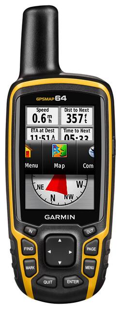
Garmin - GPSMAP 64 2.6" Handheld GPS - Yellow
- Key Specs
- Screen Size: 2.6 inches (Size of the screen, measured diagonally from corner to corner.)
- Touch Screen: false (Touch-screen devices make navigating more intuitive. Using a touch-screen display, you can do things such as tap to select, hold and drag to move items, swipe to scroll, and pinch to zoom.)
- 3D-Map View: false
- Lifetime Map Updates: false
- Topographic Maps: true
- Lifetime Traffic Updates: false
- Points Of Interest: 10000
- Programmable Routes: true
- Alerts: Other
- Integrated Camera: false
- App Compatible: true (The product can be connected to a program or software application on a mobile device, which then receives collected data from the product.)
- Wi-Fi Built-in: false (Able to connect directly to a wireless network without the use of an adapter.)
- General
- Brand: Garmin
- Model Number: 010-01199-00
- Product Name: GPSMAP 64 2.6" Handheld GPS
- Color: Yellow
- Designed Usage: Geocaching, Hiking, Outside
- Case Included: false
- Display
- Screen Size: 2.6 inches (Size of the screen, measured diagonally from corner to corner.)
- Touch Screen: false (Touch-screen devices make navigating more intuitive. Using a touch-screen display, you can do things such as tap to select, hold and drag to move items, swipe to scroll, and pinch to zoom.)
- Color Display: true
- 3D-Map View: false
- Resolution: 160 x 240 (Refers to the number of pixels, both horizontally and vertically, used to capture video/images. The higher the resolution the finer the detail that can be seen.)
- Backlit Display: true (Integrated lights allow for visibility of the display in low-light conditions.)
- Map
- Lifetime Map Updates: false
- Integrated Base Maps: true
- Map Coverage Area: Worldwide
- Map Sharing: false
- Map Provider: Other
- Number Of Waypoints: 5000
- Geocaching Mode: true
- Topographic Maps: true
- Uploadable Maps: true
- Navigation
- Lifetime Traffic Updates: false
- Points Of Interest: 10000
- Programmable Routes: true
- Voice Prompts: false
- Emergency Services Locator: false
- Electronic Compass: false
- Environmental
- Water Resistant: true (Resists some degree of water penetration.)
- Maximum Depth Of Water Resistance: 3.28 feet (Measurement of the maximum depth of water in which the product is able to resist some degree of water penetration.)
- Barometric Altimeter: false
- Sun/Moon Information: true
- Hunt/Fish Calendar: true
- Features
- Location Reporting: true
- Alerts: Other
- Integrated Camera: false
- Pedestrian Mode: true
- Text-To-Speech: false (A system that converts language text into speech.)
- MP3 Playback: false
- Storage
- Expandable Storage: true
- Memory Card Slot: true
- Memory Card Included: false (Indicates whether a memory card is included.)
- Compatibility
- App Compatible: true (The product can be connected to a program or software application on a mobile device, which then receives collected data from the product.)
- Computer Compatibility: Mac, Windows
- Unit-To-Unit Transfer: false
- Automatic Sync: false
- Works With: Cortana, Siri (Compatible with or able to be connected to other smart devices or applications.)
- Connectivity
- Bluetooth Enabled: false (The device is capable of communicating with another device via Bluetooth, provided they are within the required range of each other. A Bluetooth-enabled device must also be the same Bluetooth version or higher than the accessory it is intended to pair with.)
- Number Of USB Port(s): 1 (The total number of USB ports including all generations and versions.)
- Wi-Fi Built-in: false (Able to connect directly to a wireless network without the use of an adapter.)
- Dimensions
- Product Height: 6.38 inches (The out of box height of the item. Height is measured as the vertical distance from the bottom of the item to the top as it would be primarily used or placed.)
- Product Width: 2.5 inches (The out of box width of the item. Width is measured as the horizontal distance from one side of the item to the other as it would be primarily used or placed.)
- Product Depth: 1.5 inches (The out of box depth of the item. Depth is measured as the distance from the front of the item to the back as it would be primarily used or placed.)
- Product Weight: 0.57 pounds (The out of box weight of the item.)
- Warranty
- Warranty - Parts: 1 year limited
- Warranty - Labor: 1 year limited
- Other
- UPC: 753759115814
With a built-in worldwide base map, this Garmin GPSMAP 64 010-01199-00 handheld GPS makes it easy to find your way around internationally. The high-sensitivity GPS and GLONASS receiver ensures secure, optimal reception in a variety of environments.
- Built-in worldwide base map: With shaded relief allows you to navigate anywhere with ease. Photo navigation lets you download geotagged pictures from the Internet and then navigate to them.
- Quad-helix antenna: Tracks both GPS and GLONASS satellites simultaneously to quickly locate your position and maintain your location, even in heavy cover and deep canyons.
- 2.6" transflective TFT color screen: With 160 x 240 pixels showcases information in easy-to-read detail, even in direct sunlight. The waterproof design withstands moisture damage.
- 4GB internal memory: Offers generous storage space. The microSD card slot enables you to download additional topographic, marine and road maps for simple system expansion.
- 250,000 preloaded caches: For paperless caching from the Geocaching Web site. Stores and displays key information, including location, terrain, difficulty, hints and descriptions for enhanced functionality.
Whats Included
- Garmin GPSMAP 64 2.6" Handheld GPS
- Lanyard
- Owner's manual
- USB cable
Q: Have a Compass? Picture shows compass, but video review says the 64s has the compass not the 64
A: Yes, the GPSMAP 64 has a compass that is based off of the GPS signal, so for it to work you would need to be in motion. ^DK
A: Your GPSMAP 64 does support custom maps. You would use an image overlay to create your custom map which would be a JPEG file. Additional information on creating a custom map can be found at this FAQ link: http://support.garmin.com/support/searchSupport/simpleCase.htm?caseId={2183bd60-bf34-11de-c454-000000000000}&kbName=garmin
Here are some additional guidelines http://support.garmin.com/support/searchSupport/simpleCase.htm?caseId={9eb27dc0-6377-11df-f5aa-000000000000}&kbName=garmin for creating a custom map.
Garmin consumer electronics has accuracy to less than 3 meters (10 feet) on average. As a consumer device, they do not offer survey grade accuracy.
Your device also supports BirdsEye Satellite Imagery; a high-resolution satellite imagery that will allow you to view your surrounding area on your GPS and computer.
Q: does it have back track so you can follow your steps back out
A: I had no problems following my track back out. I don't believe it has "back track" but it shows you the exact trail you took in and allows you to follow it back out.
A: Hi Billy, Yes, with the GPSMAP 64 you will be able to mark points and name them. With this device you will also be able to go back to those points. Thanks Chris
Q: What is the accuracy of this unit. does it have a PDOP of less than 6?
A: Hello, The accuracy for all Garmin devices is around 9 to 10 feet. Thanks Chris
A: You can order online and have it shipped to the store for pick up...
Q: can you enter a street address and use this item to navigate to this street address?
A: You absolutely can, but you would need to add City Navigator NT map data to do so. (KS)
Q: Are TOPO Maps of CONUS on the unit?
A: Hello, No, this model will not have a TOPO map of the United States loaded on the device. But this units does have the option to load mapping on to it. Thanks Chris
People also viewed
 $399.99The price was $499.99
 $312.99The price was $349.99
 $499.99The price was $599.99
Today's top picks
 $449.99The price was $829.99
 $2,449.99The price was $3,199.99
 $999.98The price was $1,639.98
 $199.99The price was $249.99
 $1,099.99The price was $1,499.99
 $549.99The price was $749.99