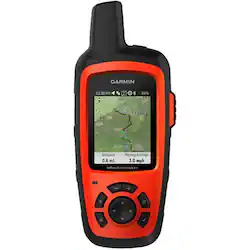
Garmin - inReach Explorer®+ 2.31" GPS with Built-In Bluetooth - Orange
- Key Specs
- Screen Size: 2.31 inches (Size of the screen, measured diagonally from corner to corner.)
- Touch Screen: false (Touch-screen devices make navigating more intuitive. Using a touch-screen display, you can do things such as tap to select, hold and drag to move items, swipe to scroll, and pinch to zoom.)
- 3D-Map View: false
- Lifetime Map Updates: false
- Topographic Maps: true
- Lifetime Traffic Updates: false
- Programmable Routes: true
- Alerts: Other
- Integrated Camera: false
- App Compatible: true (The product can be connected to a program or software application on a mobile device, which then receives collected data from the product.)
- Wi-Fi Built-in: false (Able to connect directly to a wireless network without the use of an adapter.)
- General
- Brand: Garmin
- Model Number: 010-01735-10
- Product Name: inReach Explorer®+ 2.31" GPS with Built-In Bluetooth
- Color: Orange
- Designed Usage: Geocaching, Hiking, Outside
- Case Included: false
- Display
- Screen Size: 2.31 inches (Size of the screen, measured diagonally from corner to corner.)
- Touch Screen: false (Touch-screen devices make navigating more intuitive. Using a touch-screen display, you can do things such as tap to select, hold and drag to move items, swipe to scroll, and pinch to zoom.)
- Color Display: true
- 3D-Map View: false
- Backlit Display: true (Integrated lights allow for visibility of the display in low-light conditions.)
- Map
- Lifetime Map Updates: false
- Integrated Base Maps: true
- Map Coverage Area: Canada, Mexico, U.S.
- Map Sharing: false
- Map Provider: Other
- Number Of Waypoints: 500
- Geocaching Mode: false
- Topographic Maps: true
- Uploadable Maps: false
- Navigation
- Lifetime Traffic Updates: false
- Programmable Routes: true
- Voice Prompts: false
- Emergency Services Locator: true
- Electronic Compass: true
- Environmental
- Water Resistant: true (Resists some degree of water penetration.)
- Maximum Depth Of Water Resistance: 7 feet (Measurement of the maximum depth of water in which the product is able to resist some degree of water penetration.)
- Barometric Altimeter: true
- Sun/Moon Information: false
- Hunt/Fish Calendar: false
- Features
- Location Reporting: true
- Alerts: Other
- Integrated Camera: false
- Pedestrian Mode: true
- Text-To-Speech: false (A system that converts language text into speech.)
- MP3 Playback: false
- Storage
- Expandable Storage: false
- Memory Card Slot: false
- Memory Card Included: false (Indicates whether a memory card is included.)
- Compatibility
- App Compatible: true (The product can be connected to a program or software application on a mobile device, which then receives collected data from the product.)
- Computer Compatibility: Mac, Windows
- Unit-To-Unit Transfer: false
- Automatic Sync: false
- Works With: Cortana, Siri (Compatible with or able to be connected to other smart devices or applications.)
- Connectivity
- Bluetooth Enabled: true (The device is capable of communicating with another device via Bluetooth, provided they are within the required range of each other. A Bluetooth-enabled device must also be the same Bluetooth version or higher than the accessory it is intended to pair with.)
- Number Of USB Port(s): 1 (The total number of USB ports including all generations and versions.)
- Wi-Fi Built-in: false (Able to connect directly to a wireless network without the use of an adapter.)
- Dimensions
- Product Height: 6.5 inches (The out of box height of the item. Height is measured as the vertical distance from the bottom of the item to the top as it would be primarily used or placed.)
- Product Width: 2.7 inches (The out of box width of the item. Width is measured as the horizontal distance from one side of the item to the other as it would be primarily used or placed.)
- Product Depth: 1.5 inches (The out of box depth of the item. Depth is measured as the distance from the front of the item to the back as it would be primarily used or placed.)
- Product Weight: 0.5 pounds (The out of box weight of the item.)
- Power
- Rechargeable Battery: true
- Battery Life: 100 hours (Battery life will vary depending on the product configuration, product model, applications loaded on the product, power management setting of the product and the product features used by the customer. As with all batteries, the maximum capacity of this battery will decrease with time and usage.)
- Battery Chemistry: Lithium-ion
- Interface(s): Micro-USB (Refers to the types of connections that devices use to interact and communicate with each other.)
- Charging Method: USB
- Warranty
- Warranty - Parts: 1 year limited
- Warranty - Labor: 1 year limited
- Other
- UPC: 753759168704
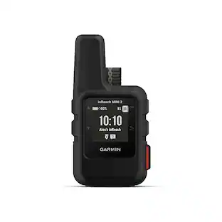
Stay on track when you're off the grid with this Garmin inReach Explorer+ satellite communicator. It supports the worldwide Iridium satellite network for two-way messaging and has topographical mapping as well as 24/7 monitoring in case of an emergency. This Garmin inReach Explorer+ satellite communicator can share your GPS location with friends and family.
- Preloaded and downloadable maps: Use preloaded DeLorme TOPO maps or download new ones via the free Earthmate® app on paired mobile devices.
- 2.31" TFT display: With 200 x 265 pixel resolution it is simple to enter destinations and navigate functions and settings.
- GEOS emergency calls: During an emergency call you can contact the GEOS International Emergency Rescue Coordination Center (IERCC) to request help. They've supported rescues in more than 140 countries, saving many lives in the process.
- Customize your route options: Full-fledged GPS on-map guidance with preloaded TOPO mapping and waypoint routings is viewable directly on the unit.
- Pair with your mobile device: The free Earthmate® app synchronizes your handheld inReach via Bluetooth® with your compatible Apple® or Android™ device so you can access unlimited maps, aerial imagery and U.S. NOAA charts.
- Get weather wherever: The optional inReach weather forecast service provides detailed updates directly to your inReach device.
- Unlimited cloud storage and trip planning are included: Free access to a cloud-powered portal to plan your trips with routes and waypoints, link your social media accounts, store all your location tracking data, and much more.
Whats Included
- Garmin inReach Explorer®+ 2.31" GPS with Built-In Bluetooth
- USB Cable
- Carabiner Clip
- Owner's Manual
Product Manuals
A: These handheld satellite communicators are designed for the outdoor enthusiast who wants to roam farther and experience more — without compromising their loved ones‘ peace of mind. From backcountry experiences to international adventures, inReach provides communication, location sharing, navigation and critical SOS functions for anyone who loves getting away from it all, on land, water or in the skies. Using the worldwide coverage of the Iridium satellite network, these go-anywhere portable devices let you exchange text messages with any cell phone number or email address — while using GPS to track and share your journey’s progress. You can also post to social media or even communicate inReach-to-inReach in the field. In case of an at-risk situation, you can also use inReach to trigger an SOS to the 24/7 monitoring center, text back and forth about the nature of your emergency, and receive confirmation when help is on the way. For more information contact us at [email protected] or visit our Support Center, https://support.garmin.com/en-US/ Thanks Jenny
A: Hi Mark, These are only the pre-loaded maps on the device, the inReach Explorer + can load up to 2 GB of maps worldwide at no additional cost.
Q: Is this for texting only, or can you speak to other people using the phone?
A: This is for texting only. You can Bluetooth it to your phone for easier texting, but no voice calls.
Q: When will the inReach Explorer be back in stock?
A: undefined
Q: Can I use the gps features like marking waypoints WITHOUT a subscription?
A: The inReach Explorer+/SE+ can be used without a subscription to mark waypoints, track recording and navigate to waypoints. For more information contact us at [email protected] or visit our Support Center, https://support.garmin.com/en-US/. Thanks Jenny
A: Yes, you can use known coordinates to create a waypoint and navitgate to that waypoint. It also provides your current coordinates. For more information contact us at [email protected] or visit our Support Center, https://support.garmin.com/en-US/ Thanks Jenny
A: The inReach Explorer + does require a subscription to use, it is not a cellular connection. Here is a link about the subcriptions that are available. https://internalsupport.garmin.com/en-US/?faq=QK8DnECaKb0JVz1ep2zKI6&productID=561269&tab=topics&textPage=1&topicTag=region_subscriptionplans For more information contact us at [email protected] or visit our Support Center, https://support.garmin.com/en-US/ Thanks Jenny
A: Yes, many hunters use them. Great device for use in the woods. For more information contact us at [email protected] or visit our Support Center, https://support.garmin.com/en-US/ Thanks Jenny
People also viewed
 $312.99The price was $349.99
 $478.00The price was $499.99
 $499.99The price was $599.99
 $420.99The price was $449.99
Today's top picks
 $479.99The price was $729.99
 $69.99The price was $129.99
 $199.99The price was $249.99
 $49.99The price was $62.99