Garmin - Tread 2 - SxS Edition Powersport Navigator 8" GPS with Built-In Bluetooth - Black
More Buying Options from Best Buy and Marketplace sellers
Related Item

Specifications
- Screen Size8 inchesTouch ScreenYes3D-Map ViewYesTopographic MapsYesProgrammable RoutesYesAlertsIncoming call, Incoming text, Personalized locations, Other
- Key Specs
- Screen Size: 8 inches (Size of the screen, measured diagonally from corner to corner.)
- Touch Screen: true (Touch-screen devices make navigating more intuitive. Using a touch-screen display, you can do things such as tap to select, hold and drag to move items, swipe to scroll, and pinch to zoom.)
- 3D-Map View: true
- Topographic Maps: true
- Programmable Routes: true
- Alerts: Incoming call, Incoming text, Personalized locations, Other
- Integrated Camera: false
- App Compatible: true (The product can be connected to a program or software application on a mobile device, which then receives collected data from the product.)
- Wi-Fi Built-in: true (Able to connect directly to a wireless network without the use of an adapter.)
- General
- Brand: Garmin
- Model Number: 010-03021-01
- Product Name: Tread 2 - SxS Edition Powersport Navigator 8" GPS with Built-In Bluetooth
- Color: Black
- Designed Usage: Outdoor
- Case Included: false
- Display
- Screen Size: 8 inches (Size of the screen, measured diagonally from corner to corner.)
- Touch Screen: true (Touch-screen devices make navigating more intuitive. Using a touch-screen display, you can do things such as tap to select, hold and drag to move items, swipe to scroll, and pinch to zoom.)
- Color Display: true
- 3D-Map View: true
- Resolution: 1280 x 800 (Refers to the number of pixels, both horizontally and vertically, used to capture video/images. The higher the resolution the finer the detail that can be seen.)
- Backlit Display: true (Integrated lights allow for visibility of the display in low-light conditions.)
- Display Type: TFT
- Map
- Integrated Base Maps: true
- Map Coverage Area: North America
- Map Sharing: true
- Geocaching Mode: false
- Topographic Maps: true
- Uploadable Maps: true
- Navigation
- Programmable Routes: true
- Voice Prompts: true
- Emergency Services Locator: true
- Electronic Compass: true
- Environmental
- Water Resistant: true (Resists some degree of water penetration.)
- Maximum Depth Of Water Resistance: 3 feet (Measurement of the maximum depth of water in which the product is able to resist some degree of water penetration.)
- Barometric Altimeter: true
- Hunt/Fish Calendar: false
- Features
- Location Reporting: true
- Alerts: Incoming call, Incoming text, Personalized locations, Other
- Integrated Camera: false
- Pedestrian Mode: false
- Hand Strap: false
- MP3 Playback: false
- Storage
- Built-in Storage: 64 gigabytes
- Expandable Storage: true
- Memory Card Slot: true
- Memory Card Included: false (Indicates whether a memory card is included.)
- Compatibility
- App Compatible: true (The product can be connected to a program or software application on a mobile device, which then receives collected data from the product.)
- Computer Compatibility: Android, Apple iOS
- Unit-To-Unit Transfer: true
- Automatic Sync: true
- Voice Assistant Built-in: Not Applicable (A digital assistant built into the device that uses voice commands to answer questions and control smart devices.)
- Connectivity
- Bluetooth Enabled: true (The device is capable of communicating with another device via Bluetooth, provided they are within the required range of each other. A Bluetooth-enabled device must also be the same Bluetooth version or higher than the accessory it is intended to pair with.)
- Number Of USB Port(s): 1 (The total number of USB ports including all generations and versions.)
- Wi-Fi Built-in: true (Able to connect directly to a wireless network without the use of an adapter.)
- Dimensions
- Product Height: 5.4 inches (The out of box height of the item. Height is measured as the vertical distance from the bottom of the item to the top as it would be primarily used or placed.)
- Product Width: 8.1 inches (The out of box width of the item. Width is measured as the horizontal distance from one side of the item to the other as it would be primarily used or placed.)
- Product Depth: 1.1 inches (The out of box depth of the item. Depth is measured as the distance from the front of the item to the back as it would be primarily used or placed.)
- Product Weight: 1.38 pounds (The out of box weight of the item.)
- Power
- Rechargeable Battery: true
- Battery Life: 6 hours (Battery life will vary depending on the product configuration, product model, applications loaded on the product, power management setting of the product and the product features used by the customer. As with all batteries, the maximum capacity of this battery will decrease with time and usage.)
- Battery Chemistry: Lithium-ion
- Interface(s): USB (Refers to the types of connections that devices use to interact and communicate with each other.)
- Charging Method: USB, 12V cigarette lighter
- Mounting
- Mount Included: true
- Mount
- Mount Type: Suction cup, Magnetic
- Warranty
- Warranty - Parts: 1 year limited
- Warranty - Labor: 1 year limited
- Other
- UPC: 753759350048
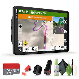
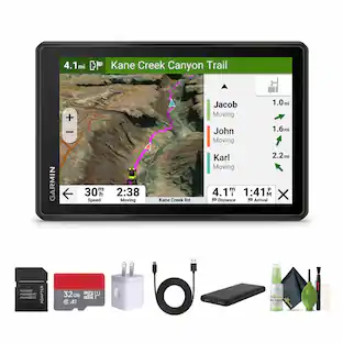
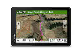
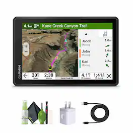
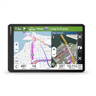
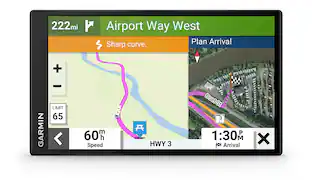
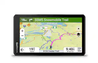
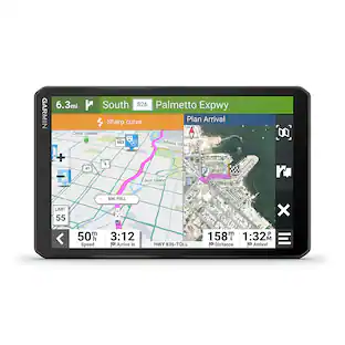
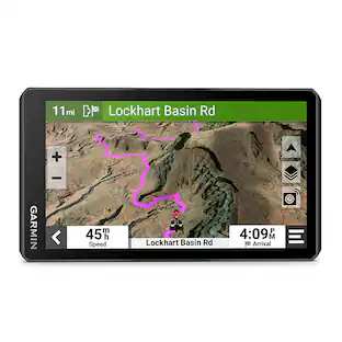
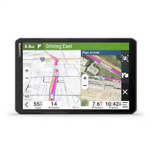
Roam the unknown with the rugged Tread 2 – SxS Edition powersport navigator. The 8” high-resolution, ultrabright and glove-friendly touchscreen will show you the way in extreme terrain, temperatures and weather (IP67 dust/water rating). Get turn-by-turn navigation for unpaved roads and trails for the kinds of places you love to ride. Venture on- and off-road with high-definition digital elevation maps, private and public land boundaries, and more. Find new places to explore with the great rides feature for off-road (searches require use of the Tread smartphone app). Download satellite imagery for high-resolution overhead views of routes and terrain (requires a connection with Wi-Fi technology). Support for Outdoor Maps+ (subscription required) allows ongoing access to additional premium map content, including burn zones, night lights and more. Track your friends’ locations with the Tread app via the group ride mobile feature when downloaded to your and each friend’s compatible smartphones enabled with BLUETOOTH technology (requires active cellular connections). Or, pair Tread 2 with the Group Ride Radio accessory for voice communication and tracking outside of a cellular network (sold separately; group tracking is available for riders using a compatible Garmin navigator and requires connection to vehicle power).
- Rugged design: The 8-inch high-resolution, ultrabright and glove-friendly touchscreen navigator is purpose-built to withstand extreme temperatures and weather (IP67 dust/water rating) for rugged off-road adventures. Tread 2 includes a roll cage mount and bare wire power cable. Plus, the upgraded processor with a 10 Hz GPS receiver delivers faster performance, including map drawing and route calculations.
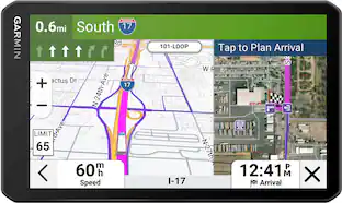
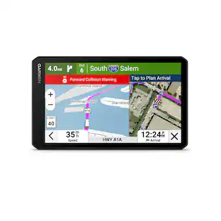
- Turn-by-turn navigation: Get turn-by-turn trail navigation for unpaved roads and trails in off-road riding areas with OpenStreetMap, U.S. Forest Service Motor Vehicle Use Maps, and Adventure Roads and Trails map content1. In North America, view off-road riding areas with trail difficulty ratings. When you head back to civilization, get directions on streets, options for more scenic routes and driver alerts for upcoming potential hazards.
- Satellite views: Download subscription-free satellite imagery directly to the device via Wi-Fi technology to see high-resolution overhead views of routes and terrain.
- Great rides: Find best-rated rides for off-road; discover new places to explore, bookmark them to sync with your navigator, rate difficulty, and upload pics (requires use of the Tread smartphone app).
- Group ride mobile: Track friends from your compatible smartphone or Tread device when you and your friends use the Tread app’s group ride mobile feature.
- Outdoor Maps+: Purchase an Outdoor Maps+ subscription for ongoing access to a wide variety of premium mapping content, including burn zones, night lights and more.
Whats Included
- Tread 2 - SxS Edition
- Locking magnet-assisted mount
- Tube mount kit
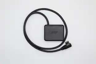
- High-current power cable
- USB cable
- Documentation
Disclaimers
- Limitations may exist in map data for some road and trail route suggestions. Always defer to all posted road signs and conditions during vehicle operation. Garmin products using OpenStreetMap data are intended to be used only as supplementary travel aids.
- Active inReach satellite subscription required to use inReach features. Some jurisdictions regulate or prohibit the use of satellite communication devices. It is the responsibility of the user to know and follow all applicable laws in the jurisdictions where the device is intended to be used.
- Product has features that may require an additional subscription. Additional fees may apply.
Q: How much built-in storage does this GPS have?
A: This GPS unit has 64 gigabytes of built-in storage.
Q: Can I upload my own maps to this GPS?
A: Yes, you can upload maps to this GPS device.
Q: Does this GPS device have bluetooth?
A: Yes, this GPS device is bluetooth enabled.
Q: Does this GPS have topographic maps?
A: Yes, this GPS comes with topographic maps.
Q: Is the display screen backlit for better viewing?
A: Yes, the display screen is backlit.
Q: Is the screen on this GPS a touch screen?
A: Yes, this GPS unit has a touch screen.
Q: What type of mount is included with this GPS?
A: This GPS includes a suction cup mount.
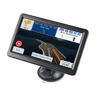
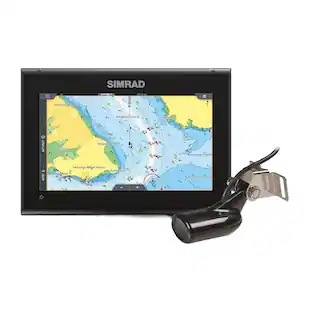
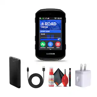
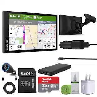
Compare similar products
Roam the unknown with the rugged Tread 2 – SxS Edition powersport navigator. The 8” high-resolution, ultrabright and glove-friendly touchscreen will show you the way in extreme terrain, temperatures and weather (IP67 dust/water rating). Get turn-by-turn navigation for unpaved roads and trails for the kinds of places you love to ride. Venture on- and off-road with high-definition digital elevation maps, private and public land boundaries, and more. Find new places to explore with the great rides feature for off-road (searches require use of the Tread smartphone app). Download satellite imagery for high-resolution overhead views of routes and terrain (requires a connection with Wi-Fi technology). Support for Outdoor Maps+ (subscription required) allows ongoing access to additional premium map content, including burn zones, night lights and more. Track your friends’ locations with the Tread app via the group ride mobile feature when downloaded to your and each friend’s compatible smartphones enabled with BLUETOOTH technology (requires active cellular connections). Or, pair Tread 2 with the Group Ride Radio accessory for voice communication and tracking outside of a cellular network (sold separately; group tracking is available for riders using a compatible Garmin navigator and requires connection to vehicle power).

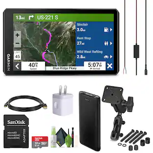
Roam the unknown with the rugged Tread 2 powersport navigator. The 6” high-resolution, ultrabright and glove-friendly touchscreen will show you the way in extreme terrain, temperatures and weather (IP67 water rating). Get turn-by-turn navigation for unpaved roads and trails for all the kinds of places you love to ride with OpenStreetMap, U.S. Forest Service Motor Vehicle Use Maps, Adventure Roads and Trails map content, and snowmobile-accessible trails and locations in the U.S. and Canada. Venture on- and off-road with high-definition digital elevation maps, private and public land boundaries, and City Navigator maps. Download subscription-free satellite imagery for high-resolution overhead views of routes and terrain (requires a connection with Wi-Fi technology). Support for Outdoor Maps+ (subscription required) allows you to download additional premium mapping such as slope angle, slope aspect, avalanche risk report and more. Track your friends’ locations with the Tread app via the group ride mobile feature when downloaded to your and each friend’s compatible smartphones (requires active cellular connections) enabled with Bluetooth technology. Or, pair Tread 2 with the 6” Group Ride Radio accessory for voice communication and tracking outside of a cellular network (sold separately; group tracking is available for riders using a compatible Garmin navigator and requires connection to vehicle power).

Simplify your drive with the Garmin DriveSmart 66 GPS navigator. Use Garmin voice assist to easily find and navigate where you want to go. The crisp 6” display and map updates of North America show you the way, providing alerts for speed changes and potential hazards ahead. Make the most of road trips with Tripadvisor traveler ratings, a directory of U.S. national parks and the HISTORY database of notable sites. Pair with the Garmin Drive app running on your compatible smartphone for on-screen access to live traffic, fuel prices, parking, weather and traffic cams to help avoid delays and keep you on your way. With Alexa Built-in (Drivers should focus on driving and only use this function when safe to do so. Must pair with the Garmin Drive app running on your compatible phone), you can ask to play music, listen to audiobooks, hear the news and more — all while you keep your hands on the wheel and eyes on the road. Not compatible with truck routes.
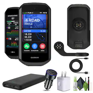
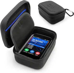
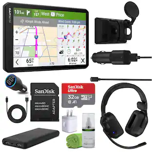
Garmin Tread 2 – SxS Edition is built for off-road riders who need reliable navigation, situational awareness, and terrain insight. The 8" ultrabright glove-friendly touchscreen is weather-resistant (IP67) and mounted for rugged rides. It delivers fast map loading and route calculation via an upgraded processor and 10 Hz GPS. Navigate trails with turn-by-turn directions using OpenStreetMap, USFS Motor Vehicle Use Maps, and more, including trail difficulty ratings. Download high-res satellite imagery to the device over Wi-Fi without a subscription. Use the Tread app to plan routes, sync data, and access live weather and group ride tracking. View public and private land boundaries, explore elevation maps, or control 12V accessories when paired with Garmin PowerSwitch. Connect with friends using Group Ride Radio for voice and GPS sharing even off-grid. Discover campgrounds, track dogs, and manage your ride from one purpose-built navigator. Bundle Iems Include: Garmin Tread 2 - SxS Edition USB Wall Charger Adapter White Cube USB Type A to USB Type C cable, 10 Feet, Black Diginerds Cleaning Kit-7 in 1
| Pros for Garmin - Tread 2 - SxS Edition Powersport Navigator 8" GPS with Built-In Bluetooth - Black | |||
|---|---|---|---|
| There were no pros for this product— | There were no pros for this product— | Ease of use, Overall Performance, GPS, Screen Size, Map Updates | There were no pros for this product— |
| Cons for Garmin - Tread 2 - SxS Edition Powersport Navigator 8" GPS with Built-In Bluetooth - Black | |||
| There were no cons for this product— | There were no cons for this product— | Battery Life, Mounting, Connectivity, Volume | There were no cons for this product— |
Specs
Reviews
Rating 1 out of 5 stars with 1 review
The vast majority of our reviews come from verified purchases. Reviews from customers may include My Best Buy members, employees, and Tech Insider Network members (as tagged). Select reviewers may receive discounted products, promotional considerations or entries into drawings for honest, helpful reviews.
Enjoy your ride Sponsored
Discover related products
 $107.99The price was $209.99