Garmin - GPSMAP 67i Rugged GPS Handheld Bundle - Black
Related Item

Compare similar products
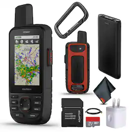
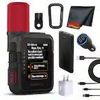
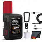
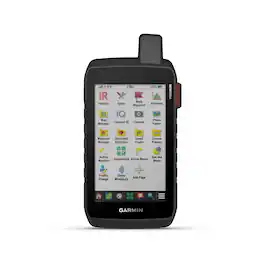
The Garmin GPSMAP 67i handheld and GPS satellite communicator is the ultimate companion for Hiking, Camping, and outdoor Adventures, offering unparalleled connectivity, navigation, and durability. With inReach satellite GPS Handheld communication, users can stay connected with two-way messaging, interactive SOS alerts & location sharing via the global Iridium network, ensuring safety and communication in locations. Featuring long battery life, multi-band GNSS support, and ABC sensors, this device provides accurate navigation data even in challenging conditions. Preloaded with detailed maps and offering premium map features with subscription. With the Garmin Messenger app and Garmin Explore app, seamless integration with smartphones enables messaging, group communication, and waypoint syncing. This handheld is built to military standards for thermal, shock and water performance (MIL-STD-810), and it's even compatible with night vision goggles. Use inReach connectivity to get detailed weather updates on the GPSMAP 67i handheld. Request weather forecasts for your current location, waypoints or destinations on your route. Access multiple global navigation satellite systems (GPS, Galileo and QZSS). Get access to multiple frequencies sent by navigation satellites for improved position accuracy in areas where GNSS signals are reflected, weak or typically don't penetrate. Built to military standards and equipped with a built-in LED flashlight, the Garmin inReach GPSMAP 67i Handheld GPS Satellite Communicator is rugged and reliable for any adventure, making it the ultimate tool for outdoor exploration and safety. Bundle Includes: Garmin GPSMAP 67i Rugged GPS Handheld with inReach Satellite Technology USB Charching Adapters Cube Microfiber Cleaning Cloth P-Bank Battery microSDHC Ultra 32GB Memory Card with Adapter

Go explore the outdoors — and stay connected to home — with the GPSMAP 67i handheld. Using inReach technology, this button-operated GPS handheld and satellite communicator enables two-way messaging and location tracking (active subscription required; some jurisdictions regulate or prohibit the use of satellite communications devices). You can also trigger an interactive SOS to Garmin Response, a 24/7 staffed emergency response coordination center. Navigate confidently with preloaded TopoActive mapping and satellite imagery. When paired with your compatible smartphone, you can access active weather forecasts and Geocaching Live. Use the Garmin Explore website or app on your compatible smartphone to help you plan trips and more, and download premium maps with an Outdoor Maps+ subscription. During extended activities, turn on expedition mode for up to 425 hours of battery life in 30-minute tracking mode.

The Garmin GPSMAP 67i handheld and GPS satellite communicator is the ultimate companion for Hiking, Camping, and outdoor Adventures, offering unparalleled connectivity, navigation, and durability. With inReach satellite GPS Handheld communication, users can stay connected with two-way messaging, interactive SOS alerts & location sharing via the global Iridium network, ensuring safety and communication in remote locations. Featuring long battery life, multi-band GNSS support, and ABC sensors, this device provides accurate navigation data even in challenging conditions. Preloaded with detailed maps and offering premium map features with subscription. With the Garmin Messenger app and Garmin Explore app, seamless integration with smartphones enables messaging, group communication, and waypoint syncing. This handheld is built to military standards for thermal, shock and water performance (MIL-STD-810), and it's even compatible with night vision goggles. Use inReach connectivity to get detailed weather updates on the GPSMAP 67i handheld. Request weather forecasts for your current location, waypoints or destinations on your route. Access multiple global navigation satellite systems (GPS, Galileo and QZSS). Get access to multiple frequencies sent by navigation satellites for improved position accuracy in areas where GNSS signals are reflected, weak or typically don't penetrate. Built to military standards and equipped with a built-in LED flashlight, the Garmin inReach GPSMAP 67i Handheld GPS Satellite Communicator is rugged and reliable for any adventure, making it the ultimate tool for outdoor exploration and safety. Bundle Includes: Garmin GPSMAP 67i Rugged GPS Handheld with inReach Satellite Technology USB Charching Adapters Cube USB 2.0 USB-A to USB-C Cable, 10 Feet Diginerds Cleaning Kit P-Bank Battery USB Car adapter SanDisk microSDHC Ultra 32GB Memory Card with Adapter
Stay on track and in touch with the rugged Montana 760i handheld GPS navigator with inReach technology. Built to guide you through all kinds of adventures, it includes TopoActive mapping and a glove-friendly 5” color touchscreen. When you go beyond the limits of cell service, stay connected with inReach technology for two-way messaging, live tracking and interactive SOS alerts to the Garmin Response team, a 24/7-staffed international emergency response coordination center (active subscription required; some jurisdictions regulate or prohibit the use of satellite communication devices). Capture and tag the location of your photos along the way with the built-in camera. Expanded 32 GB memory capacity lets you store more maps to keep your expeditions on course. High-resolution satellite imagery, available via subscription-free, direct-to-device downloads (requires a connection with Wi-Fi technology), shows a clear overhead view of your route and surrounding terrain. Get the on- or off-road capabilities you need with multi-GNSS support and ABC sensors. Add ongoing access to Outdoor Maps+ (sold separately) for a wide variety of premium mapping content. Explore longer with up to 24 hours of battery life in GPS mode and up to 432 hours in ultralow-powered expedition mode, and recharge easily with a standard USB-C cable. Plus, Montana 760i meets MIL-STD 810 for thermal, shock and vibration and is rated IPX7 for water-resistance.
Specs
Reviews
This product doesn't have any reviews yet.
Enjoy your ride Sponsored
- $368.95The price was $369.95