Garmin - zūmo® XT2 All-Terrain Motorcycle Navigator, Ultrabright 6" Sunlight Readable Display, Visual Route Planner Bundle - Black
Related Item

Specifications
- Screen Size6 inches
- Key Specs
- Screen Size: 6 inches (Size of the screen, measured diagonally from corner to corner.)
- General
- Brand: Garmin
- Model Number: 010-02781-00
- Product Name: Garmin zūmo® XT2 All-Terrain Motorcycle Navigator, Ultrabright 6" Sunlight Readable Display, Visual Route Planner Bundle
- Color: Black
- Designed Usage: Motorcycles
- Display
- Screen Size: 6 inches (Size of the screen, measured diagonally from corner to corner.)
- Color Display: true
- Map
- Integrated Base Maps: true
- Environmental
- Water Resistant: false (Resists some degree of water penetration.)
- Features
- Pedestrian Mode: false
- Storage
- Built-in Storage: 32 gigabytes
- Connectivity
- Bluetooth Enabled: true (The device is capable of communicating with another device via Bluetooth, provided they are within the required range of each other. A Bluetooth-enabled device must also be the same Bluetooth version or higher than the accessory it is intended to pair with.)
- Dimensions
- Product Height: 6.2 inches (The out of box height of the item. Height is measured as the vertical distance from the bottom of the item to the top as it would be primarily used or placed.)
- Product Width: 1 inches (The out of box width of the item. Width is measured as the horizontal distance from one side of the item to the other as it would be primarily used or placed.)
- Product Depth: 3.5 inches (The out of box depth of the item. Depth is measured as the distance from the front of the item to the back as it would be primarily used or placed.)
- Product Weight: 2.97 pounds (The out of box weight of the item.)
- Warranty
- Warranty - Parts: 1 year
- Warranty - Labor: 1 year
- Other
- UPC: 094148639376
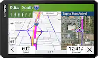
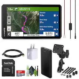
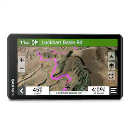
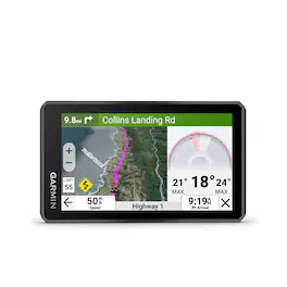
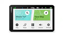
The Garmin zumo XT2 MT-S Motorcycle Navigator is a robust navigation solution designed for riders seeking enhanced functionality on the open road. Featuring a 6" ultrabright display screen with HD resolution, it offers durability against various weather conditions and rough terrain, making it suitable for all-weather riding with its IPX7 rating. With a visual route planner and simple map switching, riders can easily customize routes and access different map types, while group tracking capabilities and satellite imagery enhance navigation options. Additional features include popular path exploration, Garmin Adventurous Routing, ride summaries via the Tread app, and connectivity options such as wireless updates and live traffic/weather access. Safety features like rider alerts and incident notification, coupled with accessory control compatibility, further elevate the navigation experience, making the Garmin Zumo XT2 GPS Navigation for Motorcycle a versatile and indispensable tool for motorcycle enthusiasts. Rider alerts for hazards, live traffic, and weather updates ensure a safe and informed journey, while inReach compatibility enables emergency communication. Bluetooth connectivity allows for music streaming, and accessory control via Garmin PowerSwitch adds convenience. Switch from North America street maps to topographic maps to satellite imagery with just a tap. Plan a custom route on the device, or use the Tread app with a compatible Android or iOS smartphone. Bundle Includes: Garmin Zumo XT2 MT-S Motorcycle GPS Navigator, Motorcycle Mount with Hardware, Motorcycle Power Cable, USB Cable, USB (USA) Adapters White Cube, USB Cable 2.0 USB-A to USB-C (USB Type C) Data Charge Cable (10 Feet, Black), Diginerds Cleaning Kit, P-Bank, SanDisk micro SDHC Ultra 32GB UHS Memory Card with Adapter.
- Feature 1: Ultrabright Display: Garmin Zumo XT2 Motorcycle Navigator Features Larger and brighter 6” sunlight-readable display offers HD resolution in landscape or portrait mode, making it easy to read in any weather or light conditions. The zūmo XT2 motorcycle navigation is your prescription to hit the road, no matter where it goes. Built to withstand rain, vibration, and dust, with an IPX7 weatherproof rating, ensuring reliability in rough
- Feature 2: Visual Route Planner: Garmin Zumo XT2 Plan custom routes directly on the device or via the Tread app with a compatible smartphone. Easily toggle between on-road maps, topographic maps, and BirdsEye Direct Satellite Imagery to suit your navigation needs. Utilize The Group Ride Radio accessory to track friends or other zūmo XT2-equipped riders, even without cellular coverage. Access satellite imagery from around the world via Wi-Fi
- Feature 3: Great Rides: Discover new routes on the Tread app, bookmark them for automatic sync to your navigator, and share with other riders. Explore popular moto paths ridden by other riders to find exciting new routes. With Garmin Zumo XT2 Gps for Motorcycle Find thrilling routes with hills, curves, and sights, with 4 levels of difficulty to choose from. Access real-time traffic and weather updates, share routes with other riders, and receive
- Feature 4: InReach Compatibility: Pair with a compatible inReach satellite communicator for two-way messaging, location sharing, and SOS capabilities in emergencies. Hear turn-by-turn directions and stream music from your smartphone through a connected helmet or headset. Automatically send location information to a predetermined contact in case of an incident. In addition Stream music from your smartphone through the navigator or play MP3 files
- Feature 5: Bundle Includes: Garmin Zumo XT2 Motorcycle GPS Navigator + USB ADAPTERS (2000 mAh) White Cube + USB Cable 2.0 USB-A to USB-C (USB Type C) Data Charge Cable, 10 Feet, Black + Diginerds Cleaning Kit + P-Bank + SanDisk micro SDHC Ultra 32GB UHS Memory Card With Adapter
Whats Included
- Manufacturer and Bundle Items
- Manufacturer and Bundle Items
Compare similar products
The Garmin zumo XT2 MT-S Motorcycle Navigator is a robust navigation solution designed for riders seeking enhanced functionality on the open road. Featuring a 6" ultrabright display screen with HD resolution, it offers durability against various weather conditions and rough terrain, making it suitable for all-weather riding with its IPX7 rating. With a visual route planner and simple map switching, riders can easily customize routes and access different map types, while group tracking capabilities and satellite imagery enhance navigation options. Additional features include popular path exploration, Garmin Adventurous Routing, ride summaries via the Tread app, and connectivity options such as wireless updates and live traffic/weather access. Safety features like rider alerts and incident notification, coupled with accessory control compatibility, further elevate the navigation experience, making the Garmin Zumo XT2 GPS Navigation for Motorcycle a versatile and indispensable tool for motorcycle enthusiasts. Rider alerts for hazards, live traffic, and weather updates ensure a safe and informed journey, while inReach compatibility enables emergency communication. Bluetooth connectivity allows for music streaming, and accessory control via Garmin PowerSwitch adds convenience. Switch from North America street maps to topographic maps to satellite imagery with just a tap. Plan a custom route on the device, or use the Tread app with a compatible Android or iOS smartphone. Bundle Includes: Garmin Zumo XT2 MT-S Motorcycle GPS Navigator, Motorcycle Mount with Hardware, Motorcycle Power Cable, USB Cable, USB (USA) Adapters White Cube, USB Cable 2.0 USB-A to USB-C (USB Type C) Data Charge Cable (10 Feet, Black), Diginerds Cleaning Kit, P-Bank, SanDisk micro SDHC Ultra 32GB UHS Memory Card with Adapter.
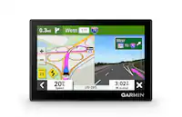
The zūmoXT2 rugged motorcycle navigator is built for adventure with a larger and brighter 6” sunlight-readable display that is built to withstand weather and handlebar vibrations. The new visual route planner lets you customize your journey with options such as choosing between a thrilling ride with extra twists and turns or experiencing a more efficient route. Start a group ride to track your friends on the zūmo display (requires the use of the Tread smartphone app). See popular moto paths and use satellite imagery to find new places to explore. Afterward, share your ride details, including elevation, acceleration and deceleration. For motorcyclists looking for the ultimate navigator, get ready to enjoy the ride.
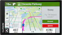
The zūmo XT3 motorcycle navigator is designed for the open road or the closed track with a bright 4.7" display and rugged design built to withstand harsh weather, vibration and rough conditions. When it’s time to hit the road, use the visual route planner with preloaded street maps, and explore the great rides database to create a custom adventure; downloadable satellite imagery shows the view from above. After your ride, see how far you leaned over with the lean angle gauge. Ride the more curvy, scenic or thrilling roads with the Garmin Adventurous Routing setting, and see popular routes on your map with the popular moto paths feature. Headed to the track? With an active Garmin Performance Package plan, record drag race splits, lap times, session performance and more with the onboard sensors. Once the gear comes off, review and share your ride details — such as lean angle, G-force, speed, elevation and more — in the Tread smartphone app.
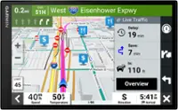
Keep an extra eye on your drive with the Garmin DriveCam 76 GPS navigator with built-in dash cam (Some jurisdictions regulate or prohibit use of the camera function of this device; it is your responsibility to know and comply with applicable laws and rights to privacy in jurisdictions where you plan to use the camera section of this device). It continually records and saves video of detected incidents. Video clips are automatically stored in the secure online Vault to view and share later using the Garmin Drive app on your compatible smartphone. Garmin voice assist lets you tell the navigator where you want to go, and the sharp 7” display with map updates of North America show you the way (With map coverage of the U.S., Mexico, Canada, Puerto Rico, U.S. Virgin Islands, Cayman Islands and Bahamas). Make the most of road trips with TripAdvisor traveler ratings, a directory of U.S. national parks, and access to live traffic, weather and fuel prices when paired with the Garmin Drive app. Not compatible with truck routes.
| Pros for Garmin - zūmo® XT2 All-Terrain Motorcycle Navigator, Ultrabright 6" Sunlight Readable Display, Visual Route Planner Bundle - Black | |||
|---|---|---|---|
| There were no pros for this product— | GPS, Overall Performance, Screen Visibility | There were no pros for this product— | Overall Performance, GPS, Camera, Screen Size, Ease of use |
Specs
Reviews
This product doesn't have any reviews yet.