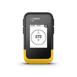
Garmin - eTrex Solar 2.2" GPS - Black
More Buying Options
Related Item

Specifications
- Screen Size2.2 inchesTouch ScreenNo3D-Map ViewNoTopographic MapsNoIntegrated CameraNoApp CompatibleYes
- Key Specs
- Screen Size: 2.2 inches (Size of the screen, measured diagonally from corner to corner.)
- Touch Screen: false (Touch-screen devices make navigating more intuitive. Using a touch-screen display, you can do things such as tap to select, hold and drag to move items, swipe to scroll, and pinch to zoom.)
- 3D-Map View: false
- Topographic Maps: false
- Integrated Camera: false
- App Compatible: true (The product can be connected to a program or software application on a mobile device, which then receives collected data from the product.)
- Wi-Fi Built-in: false (Able to connect directly to a wireless network without the use of an adapter.)
- General
- Brand: Garmin
- Model Number: 010-02782-00
- Product Name: eTrex Solar 2.2" GPS
- Color: Black
- Designed Usage: Geocaching, Hiking, Hunting, Outside
- Case Included: false
- Display
- Screen Size: 2.2 inches (Size of the screen, measured diagonally from corner to corner.)
- Touch Screen: false (Touch-screen devices make navigating more intuitive. Using a touch-screen display, you can do things such as tap to select, hold and drag to move items, swipe to scroll, and pinch to zoom.)
- Color Display: false
- 3D-Map View: false
- Resolution: 240 x 320 (Refers to the number of pixels, both horizontally and vertically, used to capture video/images. The higher the resolution the finer the detail that can be seen.)
- Display Type: LCD
- Map
- Integrated Base Maps: true
- Map Coverage Area: U.S.
- Number Of Waypoints: 1000
- Geocaching Mode: true
- Topographic Maps: false
- Environmental
- Water Resistant: true (Resists some degree of water penetration.)
- Maximum Depth Of Water Resistance: 3 feet (Measurement of the maximum depth of water in which the product is able to resist some degree of water penetration.)
- Barometric Altimeter: false
- Sun/Moon Information: true
- Features
- Integrated Camera: false
- Pedestrian Mode: true
- Compatibility
- App Compatible: true (The product can be connected to a program or software application on a mobile device, which then receives collected data from the product.)
- Computer Compatibility: Android, Apple iOS
- Connectivity
- Bluetooth Enabled: true (The device is capable of communicating with another device via Bluetooth, provided they are within the required range of each other. A Bluetooth-enabled device must also be the same Bluetooth version or higher than the accessory it is intended to pair with.)
- Number Of USB Port(s): 1 (The total number of USB ports including all generations and versions.)
- Wi-Fi Built-in: false (Able to connect directly to a wireless network without the use of an adapter.)
- Dimensions
- Product Height: 4.14 inches (The out of box height of the item. Height is measured as the vertical distance from the bottom of the item to the top as it would be primarily used or placed.)
- Product Width: 2.51 inches (The out of box width of the item. Width is measured as the horizontal distance from one side of the item to the other as it would be primarily used or placed.)
- Product Depth: 1.2 inches (The out of box depth of the item. Depth is measured as the distance from the front of the item to the back as it would be primarily used or placed.)
- Product Weight: 0.31 pounds (The out of box weight of the item.)
- Power
- Rechargeable Battery: true
- Battery Life: 200 hours (Battery life will vary depending on the product configuration, product model, applications loaded on the product, power management setting of the product and the product features used by the customer. As with all batteries, the maximum capacity of this battery will decrease with time and usage.)
- Battery Chemistry: Lithium-ion
- Battery Capacity: 6.9 milliampere hours (The amount of energy stored in the battery.)
- Interface(s): USB-C (Refers to the types of connections that devices use to interact and communicate with each other.)
- Charging Method: USB
- Mounting
- Mount Included: false
- Navigation
- Electronic Compass: true
- Warranty
- Warranty - Parts: 1 year limited
- Warranty - Labor: 1 year limited
- Other
- UPC: 753759329075
Ready. Set. Hike. With the eTrex Solar GPS handheld navigator, you’ll get solar charging that gives you unlimited battery life when used in sunny conditions (75,000 lux). You can view waypoints, track your location and find your way back to favorite spots on the 2.2” high-contrast screen. Multi-band GPS gives you access to multiple frequencies sent by navigation satellites to provide superior positional accuracy. You can pair it with the Garmin Explore app on your compatible smartphone for wireless software updates, Geocaching Live, wireless connectivity for cloud storage, weather, smart notifications and more. Plus, it’s water-resistant (rated to IPX7) and has a digital compass that’s accurate even while standing still, so you have what you need to enjoy the outdoors more.
- Display: Bright sunlight is no problem with the high-resolution 2.2” screen.
- Battery Life: Get unlimited battery life when used in sunny 75,000 lux conditions or up to 200 hours with no solar charging.
- Mutli-band GPS: Multi-band GPS gives you access to multiple frequencies sent by navigation satellites to improve positional accuracy.
- Geocaching: Get automatic cache updates from Geocaching Live, including descriptions, logs and hints. When connected to the Garmin Explore app, each find will upload to your Geocaching.com profile.
- Digital Compass: Follow your bearing on the digital compass, which provides an accurate heading even when stationary.
- Weather: When connected to the Garmin Explore app, you can get real-time forecast information, so you’re aware of the changing conditions.
- Garmin Explore app: Connect with the Garmin Explore app for wireless software updates, cloud storage, trip planning, smart notifications and additional mapping.
Whats Included
- eTrex Solar
- USB-C
- Documentation
Q: What is the screen resolution of the eTrex Solar?
A: The screen resolution is 240 x 320.
Q: How many waypoints can I store on this GPS?
A: You can store up to 1000 waypoints.
Q: How does the digital compass on this GPS device work?
A: The digital compass provides an accurate heading even when you are standing still.
Q: Is this GPS device water resistant?
A: Yes, it is water-resistant (rated to IPX7).
Q: Can I get weather information on the eTrex Solar?
A: Yes, when connected to the Garmin Explore app, you can get real-time forecast information.
Q: What type of display does the eTrex Solar have?
A: It has a 2.2" high-contrast screen.
Q: What is the battery life of the eTrex Solar GPS?
A: The eTrex Solar GPS gets unlimited battery life when used in sunny 75,000 lux conditions or up to 200 hours with no solar charging.
Q: will it do speed and does it have maps
A: Yes, the eTrex SE has the ability to view and record your speed. It does not have maps, but does pair with the Garmin Explore app that does. For more information please view our Support Center, https://support.garmin.com/en-US/. You can also contact Product Support or email us at [email protected]. Thanks Garmin
Compare similar products

Ready. Set. Hike. With the eTrex Solar GPS handheld navigator, you’ll get solar charging that gives you unlimited battery life when used in sunny conditions (75,000 lux). You can view waypoints, track your location and find your way back to favorite spots on the 2.2” high-contrast screen. Multi-band GPS gives you access to multiple frequencies sent by navigation satellites to provide superior positional accuracy. You can pair it with the Garmin Explore app on your compatible smartphone for wireless software updates, Geocaching Live, wireless connectivity for cloud storage, weather, smart notifications and more. Plus, it’s water-resistant (rated to IPX7) and has a digital compass that’s accurate even while standing still, so you have what you need to enjoy the outdoors more.
Ready. Set. Hike. With the eTrex SE GPS handheld navigator, you’ll get battery life that lasts up to 168 hours with 2 AA batteries (not included). You’ll view waypoints, track your location and find your way back to favorite spots on the 2.2” high-resolution screen. You can pair it with the Garmin Explore app on your compatible smartphone for wireless software updates, Geocaching Live, wireless connectivity for cloud storage, Active Weather, smart notifications and more. It’s water-resistant (rated to IPX7) and offers multi-GNSS support to track in more challenging environments than GPS alone. With a digital compass that’s accurate even while standing still, it provides what you need to enjoy the outdoors more.

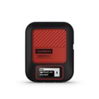
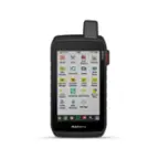
Discover new routes, and ride with confidence using the Edge Explore 2 GPS cycling computer. This navigator features a bright 3” touchscreen display, and it’s simple to set up and ready to ride straight out of the box. Ride like a local during your next on- or off-road adventure. High-contrast maps provide bike-specific, turn-by-turn navigation — and highlight popular roads and trails along with high-traffic areas. When connected to your compatible eBike, receive navigation guidance and alerts based on your bike’s battery status, assist level and range. Plus, safety features such as incident detection and Assistance let you ride with greater peace of mind (Requires setup and your smartphone to be in an area with network coverage).

Delivering our best in trucker-trusted navigation, the 6” dēzl OTR620 navigator features dēzl community insights1 from thousands of truck drivers to help you find trucker-rated parking, community-shared loading docks and other preferred trucking locations. The new wind speed weather overlay on your map, as well as road warnings for upcoming sharp curves and bridge heights, can help alert you to potentially hazardous conditions along your route. Also new, an easy search tool lets you quickly find nearby CAT Scale locations to verify your load is within legal weight limits before hitting the road. Detailed maps offer custom truck routing for the size and weight of your rig. Plus, an active PrePass account lets you receive weigh station and bypass notifications to save you time and improve efficiency. Expert arrival planning includes high-resolution aerial views of your destination for a smooth arrival at security gates, truck entrances and more. For the ultimate in-cab experience, pair with the dēzl smartphone app and add a premium dēzl headset (sold separately), so route guidance from your navigator can blend seamlessly into your headset audio stream.
Specs
Reviews
Customer Images
The vast majority of our reviews come from verified purchases. Reviews from customers may include My Best Buy members, employees, and Tech Insider Network members (as tagged). Select reviewers may receive discounted products, promotional considerations or entries into drawings for honest, helpful reviews.
- Rated 1 out of 5 stars
Unreliable
This product stopped working a little over a year after I bought it. I liked it at first but it locks up during hikes, and then won't reboot until the charge runs out, and then is recharged. This is potentially a life threatening defect.
RonS Posted
- Rated 5 out of 5 stars
Neat compass
Great device although it takes time getting used to operating it
Zach Posted