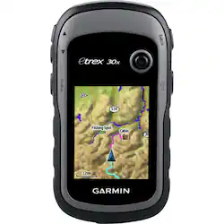
Garmin - eTrex 30x - Gray
- Key Specs
- Screen Size: 2.2 inches (Size of the screen, measured diagonally from corner to corner.)
- Touch Screen: false (Touch-screen devices make navigating more intuitive. Using a touch-screen display, you can do things such as tap to select, hold and drag to move items, swipe to scroll, and pinch to zoom.)
- 3D-Map View: false
- Lifetime Map Updates: false
- Topographic Maps: false
- Lifetime Traffic Updates: false
- Programmable Routes: true
- Alerts: Other
- Integrated Camera: false
- App Compatible: false (The product can be connected to a program or software application on a mobile device, which then receives collected data from the product.)
- Wi-Fi Built-in: false (Able to connect directly to a wireless network without the use of an adapter.)
- General
- Brand: Garmin
- Model Number: 010-01508-10
- Product Name: eTrex 30x
- Color: Gray
- Designed Usage: Hiking, Fishing, Geocaching
- Case Included: false
- Number Of Languages Supported: 16
- Display
- Screen Size: 2.2 inches (Size of the screen, measured diagonally from corner to corner.)
- Touch Screen: false (Touch-screen devices make navigating more intuitive. Using a touch-screen display, you can do things such as tap to select, hold and drag to move items, swipe to scroll, and pinch to zoom.)
- Color Display: true
- 3D-Map View: false
- Resolution: 240 x 320 (Refers to the number of pixels, both horizontally and vertically, used to capture video/images. The higher the resolution the finer the detail that can be seen.)
- Backlit Display: true (Integrated lights allow for visibility of the display in low-light conditions.)
- Map
- Lifetime Map Updates: false
- Integrated Base Maps: true
- Map Coverage Area: Worldwide
- Map Sharing: false
- Map Provider: Navteq
- Number Of Waypoints: 10000
- Geocaching Mode: true
- Topographic Maps: false
- Uploadable Maps: false
- Navigation
- Lifetime Traffic Updates: false
- Programmable Routes: true
- Voice Prompts: false
- Emergency Services Locator: false
- Electronic Compass: true
- Environmental
- Water Resistant: true (Resists some degree of water penetration.)
- Maximum Depth Of Water Resistance: 3.28 feet (Measurement of the maximum depth of water in which the product is able to resist some degree of water penetration.)
- Barometric Altimeter: true
- Sun/Moon Information: true
- Hunt/Fish Calendar: true
- Temperature Display: false
- Features
- Location Reporting: false
- Alerts: Other
- Integrated Camera: false
- Pedestrian Mode: true
- Hand Strap: false
- Text-To-Speech: false (A system that converts language text into speech.)
- MP3 Playback: false
- Storage
- Expandable Storage: true
- Memory Card Slot: true
- Memory Card Included: false (Indicates whether a memory card is included.)
- Compatibility
- App Compatible: false (The product can be connected to a program or software application on a mobile device, which then receives collected data from the product.)
- Computer Compatibility: Mac, Windows
- Unit-To-Unit Transfer: true
- Automatic Sync: false
- Works With: Cortana, Apple Home (Compatible with or able to be connected to other smart devices or applications.)
- Connectivity
- Bluetooth Enabled: false (The device is capable of communicating with another device via Bluetooth, provided they are within the required range of each other. A Bluetooth-enabled device must also be the same Bluetooth version or higher than the accessory it is intended to pair with.)
- Number Of USB Port(s): 1 (The total number of USB ports including all generations and versions.)
- Wi-Fi Built-in: false (Able to connect directly to a wireless network without the use of an adapter.)
- Dimensions
- Product Height: 4 inches (The out of box height of the item. Height is measured as the vertical distance from the bottom of the item to the top as it would be primarily used or placed.)
- Product Width: 2.1 inches (The out of box width of the item. Width is measured as the horizontal distance from one side of the item to the other as it would be primarily used or placed.)
- Product Depth: 1.3 inches (The out of box depth of the item. Depth is measured as the distance from the front of the item to the back as it would be primarily used or placed.)
- Product Weight: 0.3 pounds (The out of box weight of the item.)
- Warranty
- Warranty - Parts: 1 year limited
- Warranty - Labor: 1 year limited
- Other
- UPC: 753759142018
Garmin eTrex 30x GPS: Hike, hunt, geocache or go off-roading around the world with this versatile GPS, which also features a built-in 3-axis compass and barometric altimeter that let you determine your travel direction and altitude. Plus, you can wirelessly share stored information with other Garmin devices.
- Worldwide maps let you travel the globe: Hike, fish, geocache and go off-roading with a navigation system that will help you find your way. HotFix satellite prediction and GLONASS support ensure precision, even in heavy cover and deep canyons.
- 2.2" backlit display can be viewed in direct sunlight: So you can easily browse maps and select your route. 65K colors and 240 x 320 pixels resolution.
- Determine your precise altitude and direction: A barometric altimeter tracks changes in pressure and plots barometric pressure over time. Also features a 3-axis tilt-compensated electronic compass.
- Wirelessly sync with other devices: Simply press send to share your waypoints, tracks, routes and geocaches with your other Garmin devices and sensors.
- 3.7GB internal memory and microSD slot allow easy expansion: Load a variety of maps, including TOPO 24K, HuntView, BlueChart, City Navigator NT and BirdsEye Satellite Imagery. (Additional fees may apply.)
Whats Included
- eTrex 30x 2.2" GPS
- USB cable
- Owner's manual
- eTrex 30x 2.2" GPS
- USB cable
- Owner's manual
Q: Can this device also be used in the car?
A: It can be used in a car. But a BIG however, it will not give you a turn by turn like a dedicated car GPS. Example, it will not say turn left on main street. You have to stare at the GPS and realize... this is my turn.
Q: Can I down load maps from a computer like trails and such
A: You can CREATE maps on the fly using Google maps. There are plenty of Youtube videos to show you how to do it. I like to download trail maps from national parks and them import them into google maps... but that's just me.
Q: Does the 30x indicate current speed and distance traveled/
A: The GPS does track your active trail, so your distance is tracked. I'm not sure about the apeed.... I'm too busy enjoying nature to track how fast I'm missing it.
A: Hello, The device will capture data as a GPX file format. If ArcGIS can read GPX file format it could work but you would need to contact ArcGIS to confirm that information. Thanks Chris
A: With good satellite lock (both US and RUSSIAN enabled) I've been accurate within 9 meters. If you can't find a tree within that range, you need a new hobby.