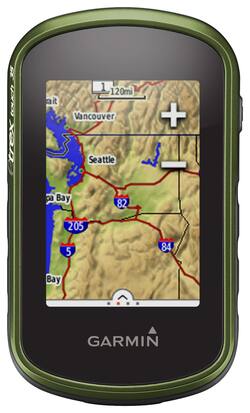
Garmin - eTrex Touch 35, GPS with Built-In Bluetooth - Green
- Key Specs
- Screen Size: 2.6 inches (Size of the screen, measured diagonally from corner to corner.)
- Touch Screen: true (Touch-screen devices make navigating more intuitive. Using a touch-screen display, you can do things such as tap to select, hold and drag to move items, swipe to scroll, and pinch to zoom.)
- 3D-Map View: true
- Lifetime Map Updates: false
- Topographic Maps: false
- Lifetime Traffic Updates: false
- Programmable Routes: true
- Alerts: Other
- Integrated Camera: false
- App Compatible: true (The product can be connected to a program or software application on a mobile device, which then receives collected data from the product.)
- Wi-Fi Built-in: false (Able to connect directly to a wireless network without the use of an adapter.)
- General
- Brand: Garmin
- Model Number: 010-01325-10
- Product Name: eTrex Touch 35, GPS with Built-In Bluetooth
- Color: Green
- Designed Usage: Geocaching, Hiking
- Case Included: false
- Number Of Languages Supported: 18
- Display
- Screen Size: 2.6 inches (Size of the screen, measured diagonally from corner to corner.)
- Touch Screen: true (Touch-screen devices make navigating more intuitive. Using a touch-screen display, you can do things such as tap to select, hold and drag to move items, swipe to scroll, and pinch to zoom.)
- Color Display: true
- 3D-Map View: true
- Resolution: 160 x 240 (Refers to the number of pixels, both horizontally and vertically, used to capture video/images. The higher the resolution the finer the detail that can be seen.)
- Backlit Display: true (Integrated lights allow for visibility of the display in low-light conditions.)
- Map
- Lifetime Map Updates: false
- Integrated Base Maps: true
- Map Coverage Area: Worldwide
- Map Sharing: false
- Map Provider: Navteq
- Number Of Waypoints: 4000
- Geocaching Mode: true
- Topographic Maps: false
- Uploadable Maps: false
- Navigation
- Lifetime Traffic Updates: false
- Programmable Routes: true
- Voice Prompts: false
- Emergency Services Locator: false
- Electronic Compass: true
- Environmental
- Water Resistant: true (Resists some degree of water penetration.)
- Maximum Depth Of Water Resistance: 3.2 feet (Measurement of the maximum depth of water in which the product is able to resist some degree of water penetration.)
- Barometric Altimeter: true
- Sun/Moon Information: true
- Hunt/Fish Calendar: true
- Features
- Alerts: Other
- Integrated Camera: false
- Pedestrian Mode: true
- Text-To-Speech: false (A system that converts language text into speech.)
- MP3 Playback: false
- Storage
- Expandable Storage: true
- Memory Card Slot: true
- Memory Card Included: false (Indicates whether a memory card is included.)
- Compatibility
- App Compatible: true (The product can be connected to a program or software application on a mobile device, which then receives collected data from the product.)
- Computer Compatibility: Mac, Windows
- Unit-To-Unit Transfer: true
- Automatic Sync: false
- Works With: Cortana, Apple Home (Compatible with or able to be connected to other smart devices or applications.)
- Connectivity
- Bluetooth Enabled: true (The device is capable of communicating with another device via Bluetooth, provided they are within the required range of each other. A Bluetooth-enabled device must also be the same Bluetooth version or higher than the accessory it is intended to pair with.)
- Number Of USB Port(s): 1 (The total number of USB ports including all generations and versions.)
- Wi-Fi Built-in: false (Able to connect directly to a wireless network without the use of an adapter.)
- Dimensions
- Product Height: 4 inches (The out of box height of the item. Height is measured as the vertical distance from the bottom of the item to the top as it would be primarily used or placed.)
- Product Width: 2.3 inches (The out of box width of the item. Width is measured as the horizontal distance from one side of the item to the other as it would be primarily used or placed.)
- Product Depth: 1.3 inches (The out of box depth of the item. Depth is measured as the distance from the front of the item to the back as it would be primarily used or placed.)
- Product Weight: 0.3 pounds (The out of box weight of the item.)
- Power
- Rechargeable Battery: false
- Battery Size: AA (The battery size required for operation.)
- Batteries Included: false (Indicates whether the product comes with the required batteries for its operation.)
- Number of Batteries Required: 2
- Warranty
- Warranty - Parts: 1 year limited
- Warranty - Labor: 1 year limited
- Other
- UPC: 753759134181
Garmin eTrex Touch 35 GPS: Hike, bike and climb without getting lost using this handheld GPS, which features a bright 2.6" touch screen and built-in Bluetooth for wireless communication. Preloaded worldwide maps and geocaches help you find your destination easily.
- Preloaded worldwide base map coverage: Along with 250,000 preloaded worldwide geocaches provide easy-to-use navigation.
- 2.6" capacitive touch screen with color display: Find your destination easily on the map and navigate functions and settings quickly.
- 3-axis tilt-compensated electronic compass: Provides accurate directional assistance. HotFix satellite prediction and GLONASS support ensure precise position locating.
- Built-in Bluetooth: Connect with a variety of compatible devices to receive e-mails, texts and alerts.
- Rugged, weather-resistant design: Withstands extreme temperatures and resists water and dust damage.
Whats Included
- eTrex Touch 35 2.6" GPS with Built-In Bluetooth
- USB cable
- Owner's manual
Q: Can you map your route and save it for later use? Also does it give you the mileage when your done?
A: Hello, Yes, the device will lay down a track that you can save and view the mileage after your done. Thanks Chris
A: Hi, The device will still funcation even it has limited GPS signal. Today's GPS receivers are extremely accurate, thanks to their parallel multi-channel design. Certain atmospheric factors and other sources of error can affect the accuracy of GPS receivers. Garmin® GPS receivers are accurate to within 15 meters (49 feet) 95% of the time. Generally, users will see accuracy within 5 to 10 meters (16 to 33 feet) under normal conditions. Thanks Chris
Q: Does it have Topographic maps built in? If not, can I load topo maps into it?
A: Topo maps are NOT built in but they can be loaded into it on the micro SD card.
Q: Can you program latitude longitude coordinates and have the gps show you where they are located
A: The device works well with a free garmin program called base camp. You can pin point coordinates as a pin or wave point and upload that to the device via the usb cable provided. If you want to trace known trail routes in national parks for example I use the website Gaiagps.com. You can log in with Facebook and then save your traces routes as a gpx file then drag them to the device through base camp. Check out YouTube on how to use it, that’s where I learned. Hope that helps
A: The eTrex Touch 35 requires 2 AA batteries (not included); NiMH or Lithium recommended. The battery life is up to 16 hours. For more information contact us at [email protected] or visit our Support Center, https://support.garmin.com/en-US/. Thanks Jenny
A: Yes, it is a great easy to use device. You can create waypoints (markers) and use the Where to? feature to navigate to them. Thanks Jenny
Q: Will this Garmin work in Africa. We are taking a trip there this summer?
A: Hi, Yes, the unit will work worldwide. Thanks Chris
Q: Will this plot out plot lines. we have the corner poles and need a straight line between them
A: With the eTrex Touch 35 you can create waypoints and then connect them. For more information contact us at [email protected] or visit our Support Center, https://support.garmin.com/en-US/. Thanks Jenny