Garmin - Tread 2 - Overland Edition, Rugged 8-inch All-Terrain Navigator for Off-The-Grid Travels - Black
Related Item

Specifications
- Screen Size8 inches
- Key Specs
- Screen Size: 8 inches (Size of the screen, measured diagonally from corner to corner.)
- General
- Brand: Garmin
- Model Number: 010-03021-00-AG2-2
- Product Name: Garmin Tread 2 - Overland Edition, Rugged 8-inch All-Terrain Navigator for Off-The-Grid Travels
- Color: Black
- Designed Usage: Outdoor
- Display
- Screen Size: 8 inches (Size of the screen, measured diagonally from corner to corner.)
- Color Display: true
- Map
- Integrated Base Maps: true
- Environmental
- Water Resistant: false (Resists some degree of water penetration.)
- Features
- Pedestrian Mode: false
- Connectivity
- Bluetooth Enabled: true (The device is capable of communicating with another device via Bluetooth, provided they are within the required range of each other. A Bluetooth-enabled device must also be the same Bluetooth version or higher than the accessory it is intended to pair with.)
- Dimensions
- Product Height: 5.4 inches (The out of box height of the item. Height is measured as the vertical distance from the bottom of the item to the top as it would be primarily used or placed.)
- Product Width: 8.1 inches (The out of box width of the item. Width is measured as the horizontal distance from one side of the item to the other as it would be primarily used or placed.)
- Product Depth: 1.1 inches (The out of box depth of the item. Depth is measured as the distance from the front of the item to the back as it would be primarily used or placed.)
- Product Weight: 4.55 pounds (The out of box weight of the item.)
- Warranty
- Warranty - Parts: 1 year
- Warranty - Labor: 1 year
- Other
- UPC: 094148733791
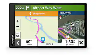
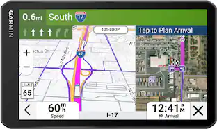
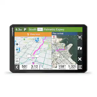
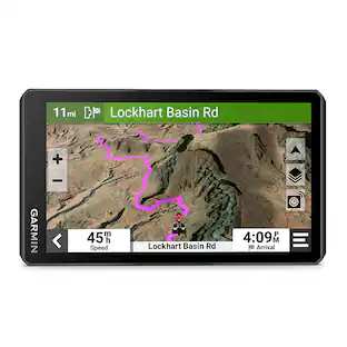
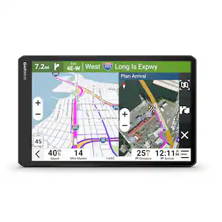
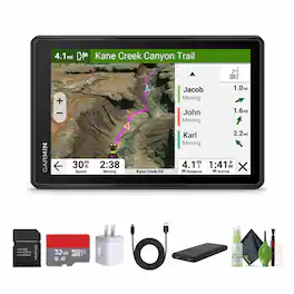
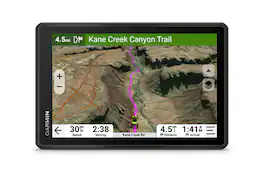
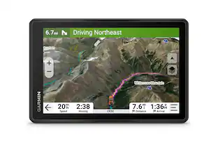
Garmin Tread 2 – Overland Edition is built for off-road navigation in , demanding environments. The 8" glove-friendly touchscreen is ultrabright and weather-sealed (IP67) for reliable use in extreme conditions. Turn-by-turn navigation covers unpaved roads and trails with data from OpenStreetMap, USFS maps, and Adventure Roads. View satellite imagery via Wi-Fi without a subscription and plan routes with custom vehicle profiles. Integrated ABC sensors offer real-time altitude, pressure, and compass data. Use the Tread app to sync routes, tracks, and waypoints across devices or share with friends using Group Ride Mobile. Access public and private land boundaries, discover 46,000+ U.S. campgrounds, and explore off-road riding areas with trail difficulty ratings. Pair with compatible Garmin devices for satellite messaging, dog tracking, or vehicle control. Designed for overlanders, adventure riders, and backcountry travelers who need dependable, high-visibility navigation. Bundle Iems Include: Garmin Tread 2 - Overland Edition USB Type A to USB Type C cable, 10 Feet, Black P-Bank Battery Universal 2-port USB Car adapter SanDisk microSDHC Ultra 32GB UHS-I Card without SD Adapter C10,U1,A1 120MB/s Sandisk MICRO SD TO SD ADAPTER Diginerds Cleaning Kit-7 in 1
- Feature 1: 8” Rugged Touchscreen Built for Expeditions: Navigate challenging terrain with the 8” high-resolution, glove-friendly display designed to withstand extreme temperatures, dust, and water (IP67 rating). Ideal for overlanders, UTV riders, and off-grid explorers who need durable, reliable navigation.
- Feature 2: Off-Road Navigation with Custom Routing: Get trail guidance using preloaded maps including unpaved roads and land use data. Route planning considers your vehicle’s dimensions for a safer experience when traveling through regions and unfamiliar terrain. Plan routes, track friends, and share GPX files using the mobile app. Compatible with vehicle control accessories for managing lighting and more. Extend off-grid communication with
- Feature 3: Preloaded Topo and Road Maps: Travel confidently with detailed topographic maps for North and South America, elevation data, and public/private land overlays. Includes road maps with custom routing for both paths and city travel.
- Feature 4: Downloadable Satellite Imagery: Access high-resolution satellite imagery without subscriptions using a Wi-Fi connection. Optional premium map layers offer additional data like terrain changes and lighting zones for deeper situational awareness during your trip.
- Feature 5: Bundle Includes: Garmin Tread 2 - Overland Edition + USB Type A to USB Type C cable, 10 Feet, Black + P-Bank Battery + Universal 2-port USB Car adapter + SanDisk microSDHC Ultra 32GB UHS-I Card without SD Adapter C10,U1,A1 120MB/s + Sandisk MICRO SD TO SD ADAPTER + Diginerds Cleaning Kit-7 in 1
Whats Included
- Manufacturer and Bundle Items
Compare similar products
Garmin Tread 2 – Overland Edition is built for off-road navigation in , demanding environments. The 8" glove-friendly touchscreen is ultrabright and weather-sealed (IP67) for reliable use in extreme conditions. Turn-by-turn navigation covers unpaved roads and trails with data from OpenStreetMap, USFS maps, and Adventure Roads. View satellite imagery via Wi-Fi without a subscription and plan routes with custom vehicle profiles. Integrated ABC sensors offer real-time altitude, pressure, and compass data. Use the Tread app to sync routes, tracks, and waypoints across devices or share with friends using Group Ride Mobile. Access public and private land boundaries, discover 46,000+ U.S. campgrounds, and explore off-road riding areas with trail difficulty ratings. Pair with compatible Garmin devices for satellite messaging, dog tracking, or vehicle control. Designed for overlanders, adventure riders, and backcountry travelers who need dependable, high-visibility navigation. Bundle Iems Include: Garmin Tread 2 - Overland Edition USB Type A to USB Type C cable, 10 Feet, Black P-Bank Battery Universal 2-port USB Car adapter SanDisk microSDHC Ultra 32GB UHS-I Card without SD Adapter C10,U1,A1 120MB/s Sandisk MICRO SD TO SD ADAPTER Diginerds Cleaning Kit-7 in 1

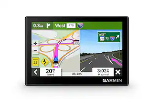
Roam the unknown with the rugged Tread 2 powersport navigator. The 6” high-resolution, ultrabright and glove-friendly touchscreen will show you the way in extreme terrain, temperatures and weather (IP67 water rating). Get turn-by-turn navigation for unpaved roads and trails for all the kinds of places you love to ride with OpenStreetMap, U.S. Forest Service Motor Vehicle Use Maps, Adventure Roads and Trails map content, and snowmobile-accessible trails and locations in the U.S. and Canada. Venture on- and off-road with high-definition digital elevation maps, private and public land boundaries, and City Navigator maps. Download subscription-free satellite imagery for high-resolution overhead views of routes and terrain (requires a connection with Wi-Fi technology). Support for Outdoor Maps+ (subscription required) allows you to download additional premium mapping such as slope angle, slope aspect, avalanche risk report and more. Track your friends’ locations with the Tread app via the group ride mobile feature when downloaded to your and each friend’s compatible smartphones (requires active cellular connections) enabled with Bluetooth technology. Or, pair Tread 2 with the 6” Group Ride Radio accessory for voice communication and tracking outside of a cellular network (sold separately; group tracking is available for riders using a compatible Garmin navigator and requires connection to vehicle power).

Roam the unknown with the rugged Tread 2 – Overland Edition all-terrain navigator for true expeditioners. The 8” high-resolution, ultrabright and glove-friendly touchscreen will show you the way. Get turn-by-turn navigation for unpaved roads and trails for the kinds of places you love to travel. Venture on- and off-road with high-definition digital elevation maps, private and public land boundaries, and City Navigator maps. View preloaded topographic maps with 3D terrain for North and South America in addition to custom street routing in North America, based on the size and weight of your rig (not available in all areas; always defer to posted road signs and road conditions). Download subscription-free satellite imagery for high-resolution overhead views of routes and terrain (requires a connection with Wi-Fi technology). Use the preloaded directory of Ultimate Public Campgrounds to find good overnight stops along your route. Support for Outdoor Maps+ (subscription required) allows ongoing access to additional premium map content including burn zones, night lights and more. Plan trips easily with the Tread app on your compatible smartphone. And pair with a Garmin PowerSwitch digital switch box (sold separately) for convenient control of your vehicle’s 12-volt electronics — including light bars, differential locks and more — right from your Tread 2 touchscreen.
Roam the unknown with the rugged Tread 2 – SxS Edition powersport navigator. The 8” high-resolution, ultrabright and glove-friendly touchscreen will show you the way in extreme terrain, temperatures and weather (IP67 dust/water rating). Get turn-by-turn navigation for unpaved roads and trails for the kinds of places you love to ride. Venture on- and off-road with high-definition digital elevation maps, private and public land boundaries, and more. Find new places to explore with the great rides feature for off-road (searches require use of the Tread smartphone app). Download satellite imagery for high-resolution overhead views of routes and terrain (requires a connection with Wi-Fi technology). Support for Outdoor Maps+ (subscription required) allows ongoing access to additional premium map content, including burn zones, night lights and more. Track your friends’ locations with the Tread app via the group ride mobile feature when downloaded to your and each friend’s compatible smartphones enabled with BLUETOOTH technology (requires active cellular connections). Or, pair Tread 2 with the Group Ride Radio accessory for voice communication and tracking outside of a cellular network (sold separately; group tracking is available for riders using a compatible Garmin navigator and requires connection to vehicle power).
Specs
Reviews
This product doesn't have any reviews yet.
Enjoy your ride Sponsored
 $899.99The price was $999.99
 $312.99The price was $349.99