Garmin - ECHOMAP Chartplotter GPS UHD2 54cv with transducer - Black
Specifications
- Screen Size5 inchesTouch ScreenNo3D-Map ViewYesChartplotterYesTopographic MapsYesProgrammable RoutesYes
- Key Specs
- Screen Size: 5 inches (Size of the screen, measured diagonally from corner to corner.)
- Touch Screen: false (Touch-screen devices make navigating more intuitive. Using a touch-screen display, you can do things such as tap to select, hold and drag to move items, swipe to scroll, and pinch to zoom.)
- 3D-Map View: true
- Chartplotter: true
- Topographic Maps: true
- Programmable Routes: true
- App Compatible: true (The product can be connected to a program or software application on a mobile device, which then receives collected data from the product.)
- Fish Finder: true
- General
- Brand: Garmin
- Model Number: 010-02591-51
- Product Name: ECHOMAP Chartplotter GPS UHD2 54cv with transducer
- Color: Black
- Designed Usage: Boating
- Display
- Screen Size: 5 inches (Size of the screen, measured diagonally from corner to corner.)
- Touch Screen: false (Touch-screen devices make navigating more intuitive. Using a touch-screen display, you can do things such as tap to select, hold and drag to move items, swipe to scroll, and pinch to zoom.)
- Color Display: true
- 3D-Map View: true
- Resolution: 800 x 480 (Refers to the number of pixels, both horizontally and vertically, used to capture video/images. The higher the resolution the finer the detail that can be seen.)
- Backlit Display: true (Integrated lights allow for visibility of the display in low-light conditions.)
- Display Type: Other
- Multi Window Display: true
- Fish Icon Display: true
- Map
- Integrated Base Maps: true
- Map Coverage Area: U.S.
- Map Provider: Navionics
- Number Of Waypoints: 5000
- Chartplotter: true
- Topographic Maps: true
- HD Mapping: true
- Optional Chart Upgrades: true
- Navigation
- Programmable Routes: true
- Voice Prompts: false
- Electronic Compass: true
- Environmental
- Water Resistant: true (Resists some degree of water penetration.)
- Maximum Depth Of Water Resistance: 3 feet (Measurement of the maximum depth of water in which the product is able to resist some degree of water penetration.)
- Hunt/Fish Calendar: true
- Features
- Location Reporting: true
- Radar: Included
- Storage
- Memory Card Slot: true
- Memory Card Included: false (Indicates whether a memory card is included.)
- Compatibility
- App Compatible: true (The product can be connected to a program or software application on a mobile device, which then receives collected data from the product.)
- Computer Compatibility: Android, Apple iOS
- Connectivity
- Bluetooth Enabled: true (The device is capable of communicating with another device via Bluetooth, provided they are within the required range of each other. A Bluetooth-enabled device must also be the same Bluetooth version or higher than the accessory it is intended to pair with.)
- Depthfinding
- Downscan Imaging: true
- Side Imaging: false
- Fish Finder: true
- Dimensions
- Product Height: 4.8 inches (The out of box height of the item. Height is measured as the vertical distance from the bottom of the item to the top as it would be primarily used or placed.)
- Product Width: 7.4 inches (The out of box width of the item. Width is measured as the horizontal distance from one side of the item to the other as it would be primarily used or placed.)
- Product Depth: 2.4 inches (The out of box depth of the item. Depth is measured as the distance from the front of the item to the back as it would be primarily used or placed.)
- Product Weight: 1.1 pounds (The out of box weight of the item.)
- Power
- Power Source: Hard wired
- Mounting
- GPS Mount Type: Flush
- Other
- UPC: 753759307080
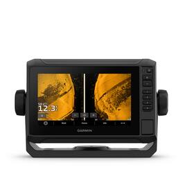
Fish like a local with the 5” or 7” ECHOMAP™ UHD2 chartplotters. See clear, sharp fish arches with Garmin traditional sonar. Use ClearVü™ scanning sonar featuring vivid color palettes for clear, high-contrast views below your boat. Know the waters you’re in as if you grew up fishing them by using built-in Garmin Navionics+™ mapping with coastal or inland content. Use built-in Wi-Fi®(Wi-Fi is a registered trademark of the Wi-Fi Alliance) connectivity to share sonar, waypoints and routes with another compatible Garmin chartplotter (sold separately). You can also pair with the free all-in-one ActiveCaptain® app on your compatible smartphone for access to the OneChart™ feature, software updates and more.
- Sonar support: With crisp, clear traditional sonar and brilliant ClearVü sonar, the fish will have nowhere to hide.
- Vivid color palettes: High-contrast vivid scanning sonar color palettes make it easier than ever to distinguish targets and structure.
- Bundle your transducer: Your ECHOMAP UHD2 device supports a variety of Garmin transducers for two types of sonar: Garmin traditional and ClearVü scanning sonars.
- Preloaded charts: Know the waters you're in as if you grew up fishing them by using built-in Garmin Navionics+ coastal or inland mapping which includes a 1-year subscription for downloadable daily updates and more.
- Wirless networking: If you have another compatible ECHOMAP UHD2 chartplotter on your boat, the 5” and 7” models can wirelessly share information — such as sonar, waypoints and routes — with them.
- Activecaptain app: Built-in Wi-Fi connectivity pairs with the free all-in-one mobile app for access to the OneChart feature, software updates, Garmin Quickdraw Community data and more.
Whats Included
- ECHOMAP UHD2 (device varies depending on selection)
- GT20-TM transducer
- Power/data cable
- Tilt mount
- Flush mount
- Hardware
- Documentation
Q: Is this chartplotter waterproof?
A: Yes, it is water-resistant up to 3 feet.
Q: What is the ActiveCaptain app used for?
A: The free ActiveCaptain app allows you to access OneChart, software updates, Garmin Quickdraw Community data, and more.
Q: Can I share data with other chartplotters?
A: Yes, the 5" and 7" models can wirelessly share information like sonar, waypoints, and routes with other compatible ECHOMAP UHD2 chartplotters.
Q: Does this device support traditional sonar?
A: Yes, the ECHOMAP UHD2 supports Garmin traditional sonar, providing crisp and clear fish arches.
Q: How does the ClearVü scanning sonar help?
A: ClearVü sonar provides clear, high-contrast views below your boat with vivid color palettes, making it easier to distinguish targets and structure.
Q: What kind of charts come preloaded on this chartplotter?
A: It comes with built-in Garmin Navionics+ coastal or inland mapping, including a 1-year subscription for downloadable daily updates.
Q: is a through hull transducer available
A: undefined
A: Yes, this can be used for ice fishing.
Compare similar products

Fish like a local with the 5” or 7” ECHOMAP™ UHD2 chartplotters. See clear, sharp fish arches with Garmin traditional sonar. Use ClearVü™ scanning sonar featuring vivid color palettes for clear, high-contrast views below your boat. Know the waters you’re in as if you grew up fishing them by using built-in Garmin Navionics+™ mapping with coastal or inland content. Use built-in Wi-Fi®(Wi-Fi is a registered trademark of the Wi-Fi Alliance) connectivity to share sonar, waypoints and routes with another compatible Garmin chartplotter (sold separately). You can also pair with the free all-in-one ActiveCaptain® app on your compatible smartphone for access to the OneChart™ feature, software updates and more.
The 7” ECHOMAP™ UHD2 touchscreen with keyed-assist chartplotter knows the water better than a local. See clear, sharp fish arches with Garmin traditional sonar. ClearVü™ and SideVü™ scanning sonars feature vivid color palettes for clear, high-contrast views all around your boat. ECHOMAP UHD2 also supports LiveScope™ sonar systems. Navigate the waters with built-in Garmin Navionics+™ cartography. Built-in Wi-Fi® connectivity lets you wirelessly share sonar, waypoints and routes with another ECHOMAP UHD2 chartplotter. Wherever you drop your line, get improved position accuracy, particularly in areas where signals are reflected or weak, with multi-band GPS. You can also pair with the free all-in-one ActiveCaptain® app on your compatible smartphone for access to the OneChart™ feature, software updates and more. The chartplotter supports NMEA 2000® networks to connect your compatible autopilots, digital switching, music, and more to view all on one screen.

See fish and structure in colorful detail with the STRIKER Vivid 7cv fishfinder. This easy-to-use 7” device now features high-contrast color palettes to make it easier to see what’s beneath the surface. It includes a GT20 transducer for best-in-class Garmin CHIRP traditional sonar and CHIRP ClearVü scanning sonar. High-sensitivity GPS lets you mark hot spots, plan routes and view your boat’s speed. Create and save maps with 1’ contours with built-in Quickdraw Contours software. Built-in Wi-Fi connectivity allows you to connect to the ActiveCaptain app with compatible smartphone to transfer waypoints, receive smart notifications and access the Garmin Quickdraw Community. STRIKER Vivid 7cv includes tilt/swivel mount plus transom and trolling motor mounting hardware and cable.

See fish and structure in colorful detail with the STRIKER Vivid 9sv fishfinder. This easy-to-use 9” device now features high-contrast color palettes to make it easier to see what’s beneath the surface. It includes support for best-in-class Garmin CHIRP traditional sonar plus CHIRP ClearVü and CHIRP SideVü scanning sonars (requires compatible transducer). High sensitivity GPS lets you mark hot spots, plan routes and view your boat’s speed. Create and save maps with 1’ contours with built-in Quickdraw Contours software. Built-in Wi-Fi connectivity allows you to connect to the ActiveCaptain app with compatible smartphone to transfer waypoints, receive smart notifications and access the Garmin Quickdraw Community.
Specs
Reviews
This product doesn't have any reviews yet.
