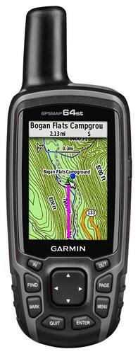
Garmin - GPSMAP 64st 2.6" Handheld GPS with Built-In Bluetooth - Gray
- Key Specs
- Screen Size: 2.6 inches (Size of the screen, measured diagonally from corner to corner.)
- Touch Screen: false (Touch-screen devices make navigating more intuitive. Using a touch-screen display, you can do things such as tap to select, hold and drag to move items, swipe to scroll, and pinch to zoom.)
- 3D-Map View: false
- Lifetime Map Updates: false
- Topographic Maps: true
- Points Of Interest: 10000
- Programmable Routes: true
- Integrated Camera: false
- General
- Product Name: GPSMAP 64st 2.6" Handheld GPS with Built-In Bluetooth
- Brand: Garmin
- Designed Usage: Geocaching, Hiking, Outside
- Case Included: false
- Model Number: 010-01199-20
- Display
- Screen Size: 2.6 inches (Size of the screen, measured diagonally from corner to corner.)
- Touch Screen: false (Touch-screen devices make navigating more intuitive. Using a touch-screen display, you can do things such as tap to select, hold and drag to move items, swipe to scroll, and pinch to zoom.)
- Color Display: true
- 3D-Map View: false
- Resolution: 160 x 240 (Refers to the number of pixels, both horizontally and vertically, used to capture video/images. The higher the resolution the finer the detail that can be seen.)
- Backlit Display: true (Integrated lights allow for visibility of the display in low-light conditions.)
- Map
- Lifetime Map Updates: false
- Integrated Base Maps: true
- Map Coverage Area: Worldwide
- Map Provider: Other
- Number Of Waypoints: 5000
- Geocaching Mode: true
- Topographic Maps: true
- Uploadable Maps: true
- Navigation
- Points Of Interest: 10000
- Programmable Routes: true
- Voice Prompts: false
- Electronic Compass: true
- Environmental
- Water Resistant: true (Resists some degree of water penetration.)
- Maximum Depth Of Water Resistance: 3.28 feet (Measurement of the maximum depth of water in which the product is able to resist some degree of water penetration.)
- Barometric Altimeter: true
- Sun/Moon Information: true
- Hunt/Fish Calendar: true
- Features
- Location Reporting: true
- Integrated Camera: false
- Hand Strap: false
- Text-To-Speech: false (A system that converts language text into speech.)
- MP3 Playback: false
- Storage
- Expandable Storage: true
- Memory Card Slot: true
- Memory Card Included: false (Indicates whether a memory card is included.)
- Compatibility
- Unit-To-Unit Transfer: true
- Automatic Sync: true
- Connectivity
- Bluetooth Enabled: true (The device is capable of communicating with another device via Bluetooth, provided they are within the required range of each other. A Bluetooth-enabled device must also be the same Bluetooth version or higher than the accessory it is intended to pair with.)
- Number Of USB Port(s): 1 (The total number of USB ports including all generations and versions.)
- Power
- Battery Life: 16 hours (Battery life will vary depending on the product configuration, product model, applications loaded on the product, power management setting of the product and the product features used by the customer. As with all batteries, the maximum capacity of this battery will decrease with time and usage.)
- Battery Size: AA (The battery size required for operation.)
- Batteries Included: false (Indicates whether the product comes with the required batteries for its operation.)
- Number of Batteries Required: 2
- Other
- UPC: 753759115852
Preloaded with TOPO U.S. 100K maps, this Garmin GPSMAP 64st 010-01199-20 handheld GPS realistically shows national, state and local parks and forests, terrain contours, elevation information, trails, rivers, lakes and more.
- Built-in worldwide base map: With preloaded TOPO U.S. 100K maps of the full U.S. and Puerto Rico and a 1-year subscription to BirdsEye Satellite Imagery allows you to navigate anywhere with ease.
- Quad-helix antenna: Tracks both GPS and GLONASS satellites simultaneously to quickly locate your position and maintain your location, even in heavy cover and deep canyons.
- 2.6" transflective TFT color screen: With 160 x 240 pixels showcases information in easy-to-read detail, even in direct sunlight. The water-resistant design withstands moisture damage.
- Bluetooth and ANT+ technologies: Let you wirelessly share waypoints, tracks, routes and geocaches to other enabled devices, including select Garmin handheld GPS units.
- 8GB internal memory: Offers generous storage space. The microSD card slot enables you to download additional topographic, marine and road maps for simple system expansion.
Whats Included
- Carabiner clip
- Garmin GPSMAP 64st 2.6" Handheld GPS with Built-In Bluetooth
- Owner's manual
- USB cable
Q: The gps is worldwide example Southamerica or Europe ?
A: The GPSMAP 64st comes with a built-in worldwide basemap with shaded relief, and comes preloaded with TOPO U.S. 100K maps that includes coverage or the full United States (including Alaska, Hawaii, and Puerto Rico). Although the worldwide basemap does include South America and Europe, it won't have nearly as much detail as the TOPO maps. Adding more maps is easy with our array of detailed topographic, marine and road maps. With 8 GB of onboard memory and microSD card slot, you can conveniently download TOPO 24K maps and hit the trail, plug in BlueChart g2 preloaded cards for a great day on the water or City Navigator NT map data for turn-by-turn routing on roads. Thanks! (KS)
Q: When this will be back in stock
A: undefined
Q: how accurate is the altimeter?
A: Hi, The accuracy of the altimeter with proper calibration is +/- 10 feet. Thanks Chris
Q: Can this unit be charged via a solar panel ? If so what type please.
A: Hello, It could be possible to charger the battery via solar panel. We haven't tested all solar panel but you would need to make sure you have Garmin NiMH Battery Pack(010-11874-00) installed in GPSMAP 64st. Below are some knowledge center articles explaining this. https://support.garmin.com/faqSearch/en-US/faq/content/lV3kmT2EjT6ZrcDJRHaYs9 https://www8.garmin.com/manuals/webhelp/gpsmap64/EN-US/GUID-3954A785-E19A-4195-A79A-BA05FA168A9D.html Thanks Chris
Q: Does this map include lakes ,rivers other waterways
A: Yes, the GPS does include rivers, lakes, and other waterways.
Q: Does the USB cord also charge battery with 12 volts
A: undefined
Q: can I locate survey pins using my deed
A: undefined
Q: Do the GPS 64st require calibration? And if so, how often? Is it free service?
A: Calibration of the compass and altimiter can be performed on the 64st, though may not be necessary. It is free to do, and instructions on doing so can be found in the owner's manual: http://www8.garmin.com/manuals/webhelp/gpsmap64/EN-US/ ^DK