Garmin - Montana 610t Camo - Camouflage
Model: 010-01534-01
SKU: 4696300
This item is no longer available in new condition. See similar items below
- Key Specs
- Screen Size: 4 inches (Size of the screen, measured diagonally from corner to corner.)
- Touch Screen: true (Touch-screen devices make navigating more intuitive. Using a touch-screen display, you can do things such as tap to select, hold and drag to move items, swipe to scroll, and pinch to zoom.)
- 3D-Map View: false
- Lifetime Map Updates: false
- Topographic Maps: false
- Lifetime Traffic Updates: false
- Programmable Routes: true
- Alerts: Other
- Integrated Camera: false
- App Compatible: true (The product can be connected to a program or software application on a mobile device, which then receives collected data from the product.)
- Wi-Fi Built-in: false (Able to connect directly to a wireless network without the use of an adapter.)
- General
- Brand: Garmin
- Model Number: 010-01534-01
- Product Name: Montana 610t Camo
- Color: Camouflage
- Designed Usage: Hiking
- Case Included: false
- Number Of Languages Supported: 5
- Display
- Screen Size: 4 inches (Size of the screen, measured diagonally from corner to corner.)
- Touch Screen: true (Touch-screen devices make navigating more intuitive. Using a touch-screen display, you can do things such as tap to select, hold and drag to move items, swipe to scroll, and pinch to zoom.)
- Color Display: true
- 3D-Map View: false
- Resolution: 272 x 480 (Refers to the number of pixels, both horizontally and vertically, used to capture video/images. The higher the resolution the finer the detail that can be seen.)
- Backlit Display: true (Integrated lights allow for visibility of the display in low-light conditions.)
- Map
- Lifetime Map Updates: false
- Integrated Base Maps: true
- Map Coverage Area: U.S., Worldwide
- Map Sharing: false
- Map Provider: Navteq
- Number Of Waypoints: 4000
- Geocaching Mode: true
- Topographic Maps: false
- Uploadable Maps: false
- Navigation
- Lifetime Traffic Updates: false
- Programmable Routes: true
- Voice Prompts: false
- Emergency Services Locator: false
- Electronic Compass: true
- Environmental
- Water Resistant: true (Resists some degree of water penetration.)
- Maximum Depth Of Water Resistance: 3 feet (Measurement of the maximum depth of water in which the product is able to resist some degree of water penetration.)
- Barometric Altimeter: true
- Sun/Moon Information: true
- Hunt/Fish Calendar: true
- Temperature Display: false
- Features
- Location Reporting: false
- Alerts: Other
- Integrated Camera: false
- Pedestrian Mode: true
- Hand Strap: false
- Text-To-Speech: false (A system that converts language text into speech.)
- MP3 Playback: false
- Storage
- Expandable Storage: true
- Memory Card Slot: true
- Memory Card Included: true (Indicates whether a memory card is included.)
- Memory Card Type: microSD card
- Compatibility
- App Compatible: true (The product can be connected to a program or software application on a mobile device, which then receives collected data from the product.)
- Computer Compatibility: Windows, Mac
- Unit-To-Unit Transfer: false
- Automatic Sync: false
- Works With: Cortana, Apple Home (Compatible with or able to be connected to other smart devices or applications.)
- Connectivity
- Bluetooth Enabled: false (The device is capable of communicating with another device via Bluetooth, provided they are within the required range of each other. A Bluetooth-enabled device must also be the same Bluetooth version or higher than the accessory it is intended to pair with.)
- Number Of USB Port(s): 1 (The total number of USB ports including all generations and versions.)
- Wi-Fi Built-in: false (Able to connect directly to a wireless network without the use of an adapter.)
- Dimensions
- Product Height: 5.7 inches (The out of box height of the item. Height is measured as the vertical distance from the bottom of the item to the top as it would be primarily used or placed.)
- Product Width: 2.9 inches (The out of box width of the item. Width is measured as the horizontal distance from one side of the item to the other as it would be primarily used or placed.)
- Product Depth: 1.4 inches (The out of box depth of the item. Depth is measured as the distance from the front of the item to the back as it would be primarily used or placed.)
- Product Weight: 0.75 pounds (The out of box weight of the item.)
- Warranty
- Warranty - Parts: 1 year limited
- Warranty - Labor: 1 year limited
- Other
- UPC: 753759143329
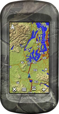
Garmin Montana 610t GPS: If you're the type who's looking for an adventure, this GPS helps make sure you stay on the right track and find your way. With a preloaded worldwide base map and TOPO U.S. 100K maps, you can successfully hike through a variety of locales across the globe. The 4" touch screen can be viewed in direct sunlight and operated while you're wearing gloves to suit your needs.
- Preloaded worldwide base map and TOPO U.S. 100K maps: Along with 250,000 preloaded worldwide geocaches from the Geocaching Web site help you find your way while hiking and adventuring.
- 4" sunlight-readable, glove-friendly TFT touch screen: With 65K colors and 272 x 480 pixels provides a clear view while you're outdoors and simplifies navigation. Works in both landscape and portrait modes.
- Enjoy reliable location data: WAAS-enabled GPS receiver with HotFix satellite prediction and GLONASS support quickly tracks your location and maintains its signal while you're in heavy cover and deep canyons.
- Stay aware of your surroundings: A 1-year BirdsEye satellite imagery subscription is included.
- Track the locations you've visited: You can easily organize and navigate through waypoints, routes and track logs using the track manager.
- Measure your climb information and see which direction you're traveling: A barometric altimeter offers precise elevation and climb data, while a 3-axis, tilt-compensated electronic compass provides accurate directional information.
- Water-resistant design: Built to withstand dust, dirt and humidity. IPX7 water rating.
- Hold even more maps: Built-in memory offers room for maps, and a microSD slot lets you expand storage (card sold separately).
- Link with other sensors and Garmin devices (sold separately): ANT+ connectivity expands your options. You can share your waypoints, tracks, routes and geocaches across devices. You can also control your VIRB action camera from up to 32.8' away.
- Connect to your computer using the USB interface: Easily connect to your computer to transfer data and more.
Whats Included
- Montana 610t 4" GPS
- AC charger and USB cable
- Lithium-ion battery
- Owner's manual
- Montana 610t 4" GPS
- AC charger and USB cable
- Lithium-ion battery
- Owner's manual
Q: Can I convert from FEET to METERS?
A: Hi Marie, Yes, the Montana 610t can convert from feet to meters. Below is an article on how to change the units of measurement on the Montana. https://www8.garmin.com/manuals/webhelp/montana610-680/EN-US/GUID-7BF5E25C-509E-4128-89D3-6B4EBC90E59F.html Thanks Chris