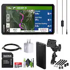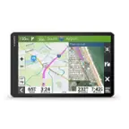
Garmin - Tread 2 Powersport Navigator 6" GPS with Built-In Bluetooth - Black
- Key Specs
- Screen Size: 6 inches (Size of the screen, measured diagonally from corner to corner.)
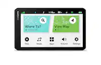
- Touch Screen: true (Touch-screen devices make navigating more intuitive. Using a touch-screen display, you can do things such as tap to select, hold and drag to move items, swipe to scroll, and pinch to zoom.)
- 3D-Map View: true
- Topographic Maps: true
- Programmable Routes: true
- Alerts: Incoming call, Incoming text, Personalized locations, Rest areas, Traffic
- Integrated Camera: true
- App Compatible: true (The product can be connected to a program or software application on a mobile device, which then receives collected data from the product.)
- Wi-Fi Built-in: true (Able to connect directly to a wireless network without the use of an adapter.)
- General
- Brand: Garmin
- Model Number: 010-02972-00
- Product Name: Tread 2 Powersport Navigator 6" GPS with Built-In Bluetooth
- Color: Black
- Designed Usage: Outside, Travel, Tracking, RV
- Case Included: false
- Display
- Screen Size: 6 inches (Size of the screen, measured diagonally from corner to corner.)
- Touch Screen: true (Touch-screen devices make navigating more intuitive. Using a touch-screen display, you can do things such as tap to select, hold and drag to move items, swipe to scroll, and pinch to zoom.)
- Color Display: true
- 3D-Map View: true
- Resolution: 1280 x 720 (Refers to the number of pixels, both horizontally and vertically, used to capture video/images. The higher the resolution the finer the detail that can be seen.)
- Backlit Display: true (Integrated lights allow for visibility of the display in low-light conditions.)
- Display Type: TFT
- Map
- Integrated Base Maps: true
- Map Coverage Area: North America
- Map Sharing: true
- Map Provider: Other
- Geocaching Mode: false
- Topographic Maps: true
- Uploadable Maps: true
- Navigation
- Programmable Routes: true
- Voice Prompts: true
- Emergency Services Locator: true
- Environmental
- Water Resistant: true (Resists some degree of water penetration.)
- Maximum Depth Of Water Resistance: 3 feet (Measurement of the maximum depth of water in which the product is able to resist some degree of water penetration.)
- Barometric Altimeter: true
- Sun/Moon Information: false
- Hunt/Fish Calendar: false
- Temperature Display: true
- Features
- Location Reporting: true
- Alerts: Incoming call, Incoming text, Personalized locations, Rest areas, Traffic
- Integrated Camera: true
- Pedestrian Mode: false
- Hand Strap: false
- MP3 Playback: false
- Storage
- Built-in Storage: 64 gigabytes
- Expandable Storage: true
- Memory Card Slot: true
- Memory Card Included: false (Indicates whether a memory card is included.)
- Compatibility
- App Compatible: true (The product can be connected to a program or software application on a mobile device, which then receives collected data from the product.)
- Computer Compatibility: Android, Apple iOS
- Unit-To-Unit Transfer: true
- Automatic Sync: true
- Voice Assistant Built-in: No (A digital assistant built into the device that uses voice commands to answer questions and control smart devices.)
- Connectivity
- Bluetooth Enabled: true (The device is capable of communicating with another device via Bluetooth, provided they are within the required range of each other. A Bluetooth-enabled device must also be the same Bluetooth version or higher than the accessory it is intended to pair with.)
- Number Of USB Port(s): 1 (The total number of USB ports including all generations and versions.)
- Wi-Fi Built-in: true (Able to connect directly to a wireless network without the use of an adapter.)
- Dimensions
- Product Height: 3.5 inches (The out of box height of the item. Height is measured as the vertical distance from the bottom of the item to the top as it would be primarily used or placed.)
- Product Width: 6.15 inches (The out of box width of the item. Width is measured as the horizontal distance from one side of the item to the other as it would be primarily used or placed.)
- Product Depth: 1 inches (The out of box depth of the item. Depth is measured as the distance from the front of the item to the back as it would be primarily used or placed.)
- Product Weight: 0.75 pounds (The out of box weight of the item.)
- Power
- Rechargeable Battery: true
- Battery Life: 7 hours (Battery life will vary depending on the product configuration, product model, applications loaded on the product, power management setting of the product and the product features used by the customer. As with all batteries, the maximum capacity of this battery will decrease with time and usage.)
- Battery Chemistry: Lithium-ion
- Interface(s): USB (Refers to the types of connections that devices use to interact and communicate with each other.)
- Charging Method: USB, 12V cigarette lighter
- Mounting
- Mount Included: true
- Warranty
- Warranty - Parts: 1 year limited
- Warranty - Labor: 1 year limited
- Other
- UPC: 753759344740
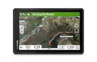
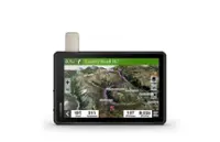
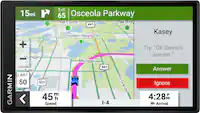
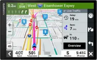
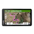
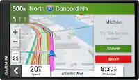
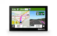
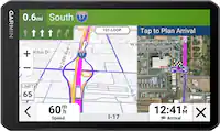
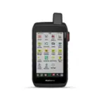
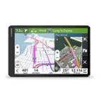
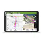
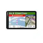
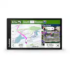
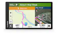
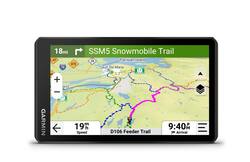
Roam the unknown with the rugged Tread 2 powersport navigator. The 6” high-resolution, ultrabright and glove-friendly touchscreen will show you the way in extreme terrain, temperatures and weather (IP67 water rating). Get turn-by-turn navigation for unpaved roads and trails for all the kinds of places you love to ride with OpenStreetMap, U.S. Forest Service Motor Vehicle Use Maps, Adventure Roads and Trails map content, and snowmobile-accessible trails and locations in the U.S. and Canada. Venture on- and off-road with high-definition digital elevation maps, private and public land boundaries, and City Navigator maps. Download subscription-free satellite imagery for high-resolution overhead views of routes and terrain (requires a connection with Wi-Fi technology). Support for Outdoor Maps+ (subscription required) allows you to download additional premium mapping such as slope angle, slope aspect, avalanche risk report and more. Track your friends’ locations with the Tread app via the group ride mobile feature when downloaded to your and each friend’s compatible smartphones (requires active cellular connections) enabled with Bluetooth technology. Or, pair Tread 2 with the 6” Group Ride Radio accessory for voice communication and tracking outside of a cellular network (sold separately; group tracking is available for riders using a compatible Garmin navigator and requires connection to vehicle power).
- Rugged Design: The 6” high-resolution, ultrabright and glove-friendly touchscreen navigator is purpose-built to withstand extreme temperatures and weather (IP67 dust/water rating) for rugged off-road adventures. The upgraded processor delivers faster performance, including map drawing and route calculations.
- Turn-by-turn navigation: Get turn-by-turn trail navigation for unpaved roads and trails in off-road riding areas with OpenStreetMap, U.S. Forest Service Motor Vehicle Use Maps and Adventure Roads and Trails map content1. View areas included throughout North America.
- Elevation maps and more: Venture off-road with high-definition digital elevation maps for dirt and snow trails, or follow City Navigator maps for street routes.
- Satellite views: Download subscription-free satellite imagery directly to the device via Wi-Fi technology to see high-resolution overhead views of routes and terrain.
- Snowmobile trails: View snowmobile trail content for select areas within the U.S. and Canadian provinces; includes snowmobile-accessible locations such as fuel stops, warming shelters, restaurants and more. View coverage areas in your state or province.
- Outdoor maps: Purchase an Outdoor Maps+ subscription for ongoing access to premium map content, including slope angle, slope aspect, avalanche risk report and more. Learn more about the Outdoor Maps+ content available for Tread devices.
Whats Included
- Tread 2
- Tube mount kit
- Power cable
- USB cable
- Documentation
Q: Does the GPS have a built-in camera?
A: The Tread 2 Powersport Navigator does have an integrated camera.
Q: What is the maximum depth of water resistance?
A: The maximum depth of water resistance for the Tread 2 Powersport Navigator is 3 feet.
A: The battery life is 7 hours.
Q: Can the GPS be used for both on- and off-road navigation?
A: This GPS unit allows you to use turn-by-turn navigation for both on-road and off-road adventures.
Q: What kind of maps are included with the GPS?
A: The Tread 2 GPS includes OpenStreetMap, U.S. Forest Service Motor Vehicle Use Maps, Adventure Roads and Trails map content, snowmobile-accessible trails and locations in the U.S. and Canada, high-definition digital elevation maps, private and public land boundaries, and City Navigator maps.
Q: Are there any additional maps that can be downloaded to the GPS?
A: Yes, you can download additional premium mapping with a subscription to Outdoor Maps+.
A: undefined
A: Yes, this gentleman has answered my question :) It has similar representation of which lane to use, exit, as other garmin drivermart devices. Here's a video: https://www.amazon.com/vdp/0b7247ab83634da789ed9832c654c4e4?product=B0FCXS8QWG&ref=cm_sw_cp_r_ib_dt_7dZLEyRbPXGD8